|
|
|
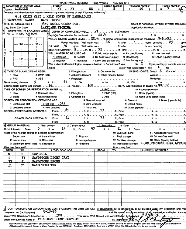
Specific Water Well Detail |
|
|
| Location Info | |||
| Owner: Pepper, Gary | Status: Constructed | ||
| Location: T10S, R7W, Sec. 8, NW NW NE | County: Lincoln | ||
| Directions: from Barnard, 4.5 mi W and 1 mi N | |||
| Latitude: 39.2039385 | Longitude: -98.1242244 | Datum NAD 27 | |
| Latitude: 39.2039442 | Longitude: -98.1245524 | Datum NAD 83 | |
| Longitude and latitude calculated by Survey from township-range-section-quarter calls. Only good to within the quarter call accuracy. | |||
| View well on interactive map | |||
| General Info | ||
| Well Depth: 71 ft. | Elevation: ft. | |
| Static Water Level: 22.4 ft. | Est. Yield: 50 gpm. | |
| Comp. Date: 18-Aug-1995 | Well Use: Domestic | |
| DWR Applic. #: | Other ID: | |
| Driller Info | ||
| Driller: Paul Pestinger Pump & Water Well Drlg., Inc. | License #: 388 | |
| Scanned Form | View scan |
|
Chemical Sample Submitted?: No
Water Well disinfected?: | ||
| Ground water encountered: 22.4 ft. , 0 ft. , 0 ft. | ||
| Pump test data: Well water was 46 ft after 1 hours pumping 25 gpm | ||
| Casing Info | ||
| Casing Type: PVC
Casing Joints: |
Diam: 5 in. to 61 ft
Diam: 0 in. to 0 ft Diam: 0 in. to 0 ft | |
| Casing height above land surface: in
Casing Weight: lbs/ft Wall thickness or gauge no.: | ||
| Screen and Perforation Info | ||
| Screen Type: PVC | Screen Openings: Mill slot | |
| Screen-perforated intervals | From: 61 ft to 71 ft
From: 0 ft to 0 ft From: 0 ft to 0 ft | |
| Gravel pack intervals | From: ft to ft | |
| Grout Info | ||
| Grout used: Bentonite | From: 0 to 25 ft
From: 47 to 51 ft From: 0 to 0 ft | |
| Source of Possible Contamination | ||
| Source: OTHER | ||
| Direction from well: | Distance: 0 ft | |
| Lithologic Log
(Log data entered by KGS.) | ||
| From: 0 ft. to 1 ft. | top soil | |
| From: 1 ft. to 33 ft. | sandstone, light gray | |
| From: 33 ft. to 51 ft. | sandstone, brown | |
| From: 51 ft. to 71 ft. | sandstone, tan | |