|
|
|
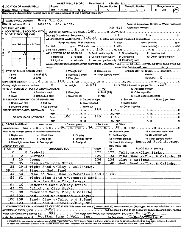
Specific Water Well Detail |
|
|
| Location Info | |||
| Owner: Home Oil Company | Status: Constructed | ||
| Location: T6S, R29W, Sec. 9, NE NE SW | County: Sheridan | ||
| Directions: | |||
| Latitude: 39.5449601 | Longitude: -100.5630571 | Datum NAD 27 | |
| Latitude: 39.5449641 | Longitude: -100.5634789 | Datum NAD 83 | |
| Longitude and latitude calculated by Survey from township-range-section-quarter calls. Only good to within the quarter call accuracy. | |||
| View well on interactive map | |||
| General Info | ||
| Well Depth: 140 ft. | Elevation: ft. | |
| Static Water Level: 125.23 ft. | Est. Yield: gpm. | |
| Comp. Date: 08-Aug-1995 | Well Use: Monitoring well/observation/piezometer | |
| DWR Applic. #: | Other ID: MW 13 | |
| Driller Info | ||
| Driller: Woofter Pump & Well, Inc. | License #: 554 | |
| Scanned Form | View scan |
|
Chemical Sample Submitted?: No
Water Well disinfected?: | ||
| Ground water encountered: 0 ft. , 0 ft. , 0 ft. | ||
| Pump test data: Well water was 0 ft after 0 hours pumping 0 gpm | ||
| Casing Info | ||
| Casing Type: PVC
Casing Joints: |
Diam: 4 in. to 110 ft
Diam: 0 in. to 0 ft Diam: 0 in. to 0 ft | |
| Casing height above land surface: in
Casing Weight: lbs/ft Wall thickness or gauge no.: | ||
| Screen and Perforation Info | ||
| Screen Type: PVC | Screen Openings: Saw cut | |
| Screen-perforated intervals | From: 110 ft to 140 ft
From: 0 ft to 0 ft From: 0 ft to 0 ft | |
| Gravel pack intervals | From: ft to ft | |
| Grout Info | ||
| Grout used: Cement grout, Bentonite | From: 0 to 94 ft
From: 94 to 100 ft From: 0 to 0 ft | |
| Source of Possible Contamination | ||
| Source: OTHER | ||
| Direction from well: | Distance: 0 ft | |
| Lithologic Log
(Log data entered by KGS.) | ||
| From: 0 ft. to .8 ft. | Asphalt | |
| From: .8 ft. to 2 ft. | Surface | |
| From: 2 ft. to 20 ft. | Loess | |
| From: 20 ft. to 35 ft. | Clay with caliche streaks | |
| From: 35 ft. to 39.5 ft. | Tight sand with clay and caliche streak | |
| From: 39.5 ft. to 44 ft. | Fine to medium sand | |
| From: 44 ft. to 54 ft. | Fine to medium sand with cemented sand streaks | |
| From: 54 ft. to 61 ft. | Tight fine sand with cemented sand and a few fine clay layers | |
| From: 61 ft. to 65 ft. | Cemented sand with clay streaks | |
| From: 65 ft. to 72 ft. | Caliche and clay streaks | |
| From: 72 ft. to 88 ft. | Cemented sand, clay and caliche | |
| From: 88 ft. to 100 ft. | Medium sand with cemented and clay streak | |
| From: 100 ft. to 108 ft. | Sandy clay with caliche and s. sand | |
| From: 108 ft. to 123 ft. | Medium sand and gravel with clay streak | |
| From: 123 ft. to 129 ft. | Caliche with clay streaks | |
| From: 129 ft. to 134 ft. | Fine sand with clay and caliche streak | |
| From: 134 ft. to 138 ft. | Clay and caliche | |
| From: 138 ft. to 140 ft. | Medium sand with clay and caliche | |