|
|
|
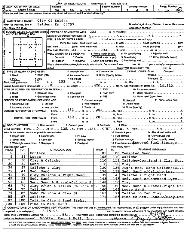
Specific Water Well Detail |
|
|
| Location Info | |||
| Owner: City of Selden | Status: Constructed | ||
| Location: T6S, R29W, Sec. 9, NW SW NE | County: Sheridan | ||
| Directions: | |||
| Latitude: 39.5485859 | Longitude: -100.5606695 | Datum NAD 27 | |
| Latitude: 39.5485899 | Longitude: -100.5610913 | Datum NAD 83 | |
| Longitude and latitude calculated by Survey from township-range-section-quarter calls. Only good to within the quarter call accuracy. | |||
| View well on interactive map | |||
| General Info | ||
| Well Depth: 203 ft. | Elevation: ft. | |
| Static Water Level: 126 ft. | Est. Yield: gpm. | |
| Comp. Date: 15-Aug-1995 | Well Use: Public Water Supply | |
| DWR Applic. #: | Other ID: | |
| Links | |
| No Wizard information available. | |
| View info from WIMAS Water Right Data base... | |
| Driller Info | ||
| Driller: Woofter Pump & Well, Inc. | License #: 554 | |
| Scanned Form | View scan |
|
Chemical Sample Submitted?: No
Water Well disinfected?: | ||
| Ground water encountered: 0 ft. , 0 ft. , 0 ft. | ||
| Pump test data: Well water was 0 ft after 0 hours pumping 0 gpm | ||
| Casing Info | ||
| Casing Type: PVC
Casing Joints: |
Diam: 12 in. to 153 ft
Diam: 0 in. to 0 ft Diam: 0 in. to 0 ft | |
| Casing height above land surface: in
Casing Weight: lbs/ft Wall thickness or gauge no.: | ||
| Screen and Perforation Info | ||
| Screen Type: PVC | Screen Openings: Saw cut | |
| Screen-perforated intervals | From: 153 ft to 203 ft
From: 0 ft to 0 ft From: 0 ft to 0 ft | |
| Gravel pack intervals | From: ft to ft | |
| Grout Info | ||
| Grout used: Cement grout, Bentonite | From: 0 to 135 ft
From: 135 to 140 ft From: 0 to 0 ft | |
| Source of Possible Contamination | ||
| Source: OTHER | ||
| Direction from well: | Distance: 0 ft | |
| Lithologic Log
(Log data entered by KGS.) | ||
| From: 0 ft. to 2 ft. | Surface | |
| From: 2 ft. to 23 ft. | Loess | |
| From: 23 ft. to 30 ft. | Clay and caliche | |
| From: 30 ft. to 34 ft. | Sand | |
| From: 34 ft. to 37 ft. | Caliche and clay | |
| From: 37 ft. to 41 ft. | Medium sand | |
| From: 41 ft. to 49 ft. | Clay caliche and tight sand | |
| From: 49 ft. to 52 ft. | Medium sand | |
| From: 52 ft. to 63 ft. | Medium sand and gravel, caliche streak | |
| From: 63 ft. to 74 ft. | Clay with tan and yellow caliche streak | |
| From: 74 ft. to 75 ft. | Caliche | |
| From: 75 ft. to 85 ft. | Sand caliche and clay streak | |
| From: 85 ft. to 87 ft. | Caliche | |
| From: 87 ft. to 100 ft. | Caliche clay and sand streaks | |
| From: 100 ft. to 105 ft. | Fine to medium sand | |
| From: 105 ft. to 108 ft. | Cemented sand | |
| From: 108 ft. to 110 ft. | Caliche | |
| From: 110 ft. to 118 ft. | Caliche, cemented sand, and clay streak | |
| From: 118 ft. to 120 ft. | Clay | |
| From: 120 ft. to 136 ft. | Tight medium sand caliche and clay layer | |
| From: 136 ft. to 139 ft. | Medium sand with caliche lens | |
| From: 139 ft. to 143 ft. | Caliche and tight sand | |
| From: 143 ft. to 148 ft. | Medium sand with cemented layers | |
| From: 148 ft. to 150 ft. | Clay | |
| From: 150 ft. to 160 ft. | Medium sand and gravel, tight streak | |
| From: 160 ft. to 163 ft. | Loose sand | |
| From: 163 ft. to 171 ft. | Yellow to tan clay | |
| From: 171 ft. to 185 ft. | Fine to medium sand with clay streak | |