|
|
|
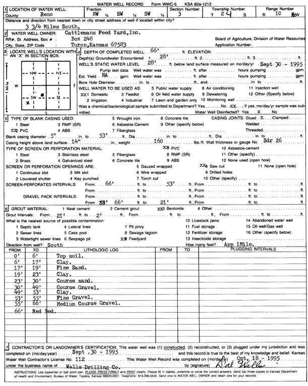
Specific Water Well Detail |
|
|
| Location Info | |||
| Owner: Cattlemans Feed Yard, Inc. | Status: Constructed | ||
| Location: T24S, R10W, Sec. 3, NW SW SW | County: Reno | ||
| Directions: | |||
| Latitude: 37.9871335 | Longitude: -98.4159818 | Datum NAD 27 | |
| Latitude: 37.9871479 | Longitude: -98.4163326 | Datum NAD 83 | |
| Longitude and latitude calculated by Survey from township-range-section-quarter calls. Only good to within the quarter call accuracy. | |||
| View well on interactive map | |||
| General Info | ||
| Well Depth: 66 ft. | Elevation: ft. | |
| Static Water Level: 28 ft. | Est. Yield: gpm. | |
| Comp. Date: 30-Sep-1995 | Well Use: Domestic | |
| DWR Applic. #: | Other ID: | |
| Driller Info | ||
| Driller: Dal Wells Drilling Co. | License #: 112 | |
| Scanned Form | View scan |
|
Chemical Sample Submitted?: No
Water Well disinfected?: | ||
| Ground water encountered: 28 ft. , 0 ft. , 0 ft. | ||
| Pump test data: Well water was 0 ft after 0 hours pumping 0 gpm | ||
| Casing Info | ||
| Casing Type: PVC
Casing Joints: |
Diam: 5 in. to 53 ft
Diam: 0 in. to 0 ft Diam: 0 in. to 0 ft | |
| Casing height above land surface: in
Casing Weight: lbs/ft Wall thickness or gauge no.: | ||
| Screen and Perforation Info | ||
| Screen Type: PVC | Screen Openings: Saw cut | |
| Screen-perforated intervals | From: 66 ft to 53 ft
From: 0 ft to 0 ft From: 0 ft to 0 ft | |
| Gravel pack intervals | From: ft to ft | |
| Grout Info | ||
| Grout used: Bentonite | From: 21 to 2 ft
From: 0 to 0 ft From: 0 to 0 ft | |
| Source of Possible Contamination | ||
| Source: Feedyard | ||
| Direction from well: S | Distance: 1 ft | |
| Lithologic Log
(Log data entered by KGS.) | ||
| From: 0 ft. to 6 ft. | top soil | |
| From: 6 ft. to 17 ft. | clay | |
| From: 17 ft. to 19 ft. | fine sand | |
| From: 19 ft. to 23 ft. | clay | |
| From: 23 ft. to 30 ft. | coarse sand | |
| From: 30 ft. to 49 ft. | coarse gravel | |
| From: 49 ft. to 53 ft. | clay | |
| From: 53 ft. to 55 ft. | fine gravel | |
| From: 55 ft. to 66 ft. | medium coarse gravel | |
| From: 66 ft. to ft. | red bed | |