|
|
|
Specific Water Well Detail |
|
|
| Location Info | |||
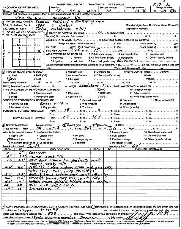
| Owner: Texaco Refining and Marketing, Inc | Status: Constructed | ||
| Location: T12S, R24E, Sec. 10, SE SE NE | County: Johnson | ||
| Directions: 5902 Quivira, Shawnee | |||
| Latitude: 39.0228941 | Longitude: -94.7248214 | Datum NAD 27 | |
| Latitude: 39.0228995 | Longitude: -94.7250591 | Datum NAD 83 | |
| Longitude and latitude calculated by Survey from township-range-section-quarter calls. Only good to within the quarter call accuracy. | |||
| View well on interactive map | |||
| General Info | ||
| Well Depth: 15 ft. | Elevation: ft. | |
| Static Water Level: ft. | Est. Yield: gpm. | |
| Comp. Date: 14-Sep-1995 | Well Use: Monitoring well/observation/piezometer | |
| DWR Applic. #: | Other ID: MW 2 | |
| Driller Info | ||
| Driller: Funkee Drilling Service | License #: 575 | |
| Scanned Form | View scan |
|
Chemical Sample Submitted?: No
Water Well disinfected?: | ||
| Ground water encountered: 0 ft. , 0 ft. , 0 ft. | ||
| Pump test data: Well water was 0 ft after 0 hours pumping 0 gpm | ||
| Casing Info | ||
| Casing Type: PVC
Casing Joints: |
Diam: 2 in. to 5 ft
Diam: 0 in. to 0 ft Diam: 0 in. to 0 ft | |
| Casing height above land surface: in
Casing Weight: lbs/ft Wall thickness or gauge no.: | ||
| Screen and Perforation Info | ||
| Screen Type: PVC | Screen Openings: Mill slot | |
| Screen-perforated intervals | From: 5 ft to 15 ft
From: 0 ft to 0 ft From: 0 ft to 0 ft | |
| Gravel pack intervals | From: ft to ft | |
| Grout Info | ||
| Grout used: Cement grout, Bentonite | From: .3 to 3 ft
From: 3 to 4.5 ft From: 0 to 0 ft | |
| Source of Possible Contamination | ||
| Source: Sewer lines | ||
| Direction from well: S | Distance: 60 ft | |
| Lithologic Log
(Log data entered by KGS.) | ||
| From: 0 ft. to .5 ft. | concrete | |
| From: .5 ft. to 1 ft. | coarse sand fill | |
| From: 1 ft. to 2.6 ft. | clayey sandy silt, soft, dark brown, low plasticity, moist | |
| From: 2.6 ft. to 9 ft. | silty clay, yellowish brown, medium stiff, moderate plasticity, small roots, termites | |
| From: 9 ft. to 11.5 ft. | silty clay, reddish brown, medium stiff, moist | |
| From: 11.5 ft. to 13.6 ft. | clay, greenish brown, very stiff, wet | |
| From: 13.6 ft. to 14 ft. | silty clay, reddish brown mottled with dark brown, medium stiff, wet | |
| From: 14 ft. to 15 ft. | limestone | |