|
|
|
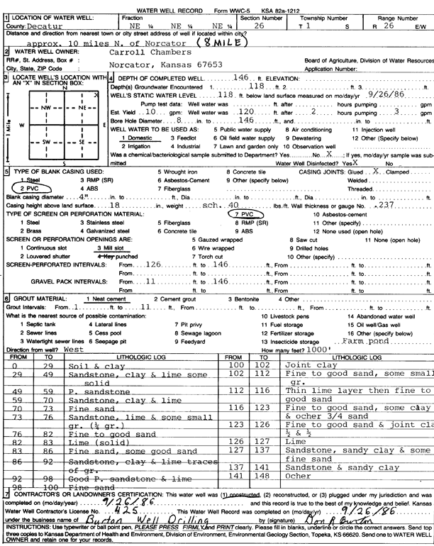
Specific Water Well Detail |
|
|
| Location Info | |||
| Owner: Chambers, Carroll | Status: Constructed | ||
| Location: T1S, R26W, Sec. 26, NE NE NE | County: Decatur | ||
| Directions: from Norcatur, 10 mi N (8 mi) | |||
| Latitude: 39.9423423 | Longitude: -100.1981984 | Datum NAD 27 | |
| Latitude: 39.9423477 | Longitude: -100.1986134 | Datum NAD 83 | |
| Longitude and latitude calculated by Survey from township-range-section-quarter calls. Only good to within the quarter call accuracy. | |||
| View well on interactive map | |||
| General Info | ||
| Well Depth: 146 ft. | Elevation: ft. | |
| Static Water Level: 118 ft. | Est. Yield: 10 gpm. | |
| Comp. Date: 26-Sep-1986 | Well Use: Domestic | |
| DWR Applic. #: | Other ID: | |
| Driller Info | ||
| Driller: Burton Well Drilling, Inc. | License #: 425 | |
| Scanned Form | View scan |
|
Chemical Sample Submitted?: No
Water Well disinfected?: | ||
| Ground water encountered: 118 ft. , 0 ft. , 0 ft. | ||
| Pump test data: Well water was 0 ft after 0 hours pumping 0 gpm | ||
| Casing Info | ||
| Casing Type: PVC
Casing Joints: |
Diam: 4 in. to 0 ft
Diam: 0 in. to 0 ft Diam: 0 in. to 0 ft | |
| Casing height above land surface: in
Casing Weight: lbs/ft Wall thickness or gauge no.: | ||
| Screen and Perforation Info | ||
| Screen Type: PVC | Screen Openings: Mill slot | |
| Screen-perforated intervals | From: 126 ft to 146 ft
From: 0 ft to 0 ft From: 0 ft to 0 ft | |
| Gravel pack intervals | From: ft to ft | |
| Grout Info | ||
| Grout used: Neat cement | From: 1 to 11 ft
From: 0 to 0 ft From: 0 to 0 ft | |
| Source of Possible Contamination | ||
| Source: OTHER | ||
| Direction from well: | Distance: 0 ft | |
| Lithologic Log
(Log data entered by KGS.) | ||
| From: 0 ft. to 29 ft. | soil and clay | |
| From: 29 ft. to 49 ft. | sandstone, clay and lime some solid | |
| From: 49 ft. to 59 ft. | porous sandstone | |
| From: 59 ft. to 70 ft. | sandstone, clay and lime | |
| From: 70 ft. to 73 ft. | fine sand | |
| From: 73 ft. to 76 ft. | sandstone, lime and some small gravel (0.25 gravel) | |
| From: 76 ft. to 82 ft. | fine to good sand | |
| From: 82 ft. to 83 ft. | lime (solid) | |
| From: 83 ft. to 86 ft. | fine sand, some good sand | |
| From: 86 ft. to 92 ft. | sandstone, clay and lime traces of gravel | |
| From: 92 ft. to 98 ft. | good porous sandstone and lime | |
| From: 98 ft. to 100 ft. | fine sand | |
| From: 100 ft. to 102 ft. | joint clay | |
| From: 102 ft. to 112 ft. | fine to good sand, some small gravel | |
| From: 112 ft. to 116 ft. | thin lime layer then fine to good sand | |
| From: 116 ft. to 123 ft. | fine to good sand, some clay and ochre 3/4 sand | |
| From: 123 ft. to 126 ft. | fine to good sand and joint clay, half and half | |
| From: 126 ft. to 127 ft. | lime | |
| From: 127 ft. to 137 ft. | sandstone, sandy clay and some fine sand | |
| From: 137 ft. to 141 ft. | sandstone and sandy clay | |
| From: 141 ft. to 148 ft. | ochre | |