|
|
|
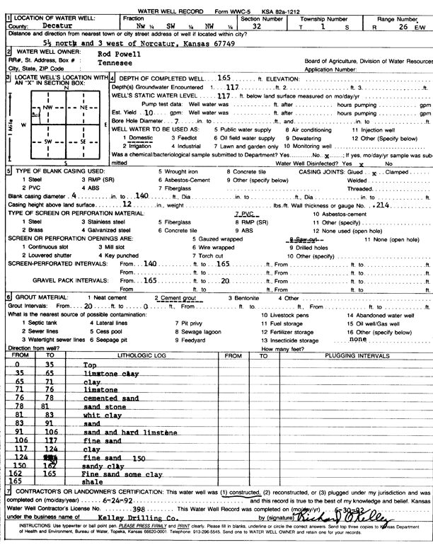
Specific Water Well Detail |
|
|
| Location Info | |||
| Owner: Powell, Rod | Status: Constructed | ||
| Location: T1S, R26W, Sec. 32, NW SW NW | County: Decatur | ||
| Directions: from Norcatur, 5.5 mi N and 3 mi W | |||
| Latitude: 39.9247552 | Longitude: -100.2713509 | Datum NAD 27 | |
| Latitude: 39.9247605 | Longitude: -100.2717688 | Datum NAD 83 | |
| Longitude and latitude calculated by Survey from township-range-section-quarter calls. Only good to within the quarter call accuracy. | |||
| View well on interactive map | |||
| General Info | ||
| Well Depth: 165 ft. | Elevation: ft. | |
| Static Water Level: 117 ft. | Est. Yield: 10 gpm. | |
| Comp. Date: 24-Jun-1992 | Well Use: Domestic | |
| DWR Applic. #: | Other ID: | |
| Driller Info | ||
| Driller: Richard O. Kelley Drilling Co. | License #: 398 | |
| Scanned Form | View scan |
|
Chemical Sample Submitted?: No
Water Well disinfected?: | ||
| Ground water encountered: 117 ft. , 0 ft. , 0 ft. | ||
| Pump test data: Well water was 0 ft after 0 hours pumping 0 gpm | ||
| Casing Info | ||
| Casing Type: PVC
Casing Joints: |
Diam: 4 in. to 140 ft
Diam: 0 in. to 0 ft Diam: 0 in. to 0 ft | |
| Casing height above land surface: in
Casing Weight: lbs/ft Wall thickness or gauge no.: | ||
| Screen and Perforation Info | ||
| Screen Type: PVC | Screen Openings: Saw cut | |
| Screen-perforated intervals | From: 140 ft to 165 ft
From: 0 ft to 0 ft From: 0 ft to 0 ft | |
| Gravel pack intervals | From: ft to ft | |
| Grout Info | ||
| Grout used: Cement grout | From: 0 to 20 ft
From: 0 to 0 ft From: 0 to 0 ft | |
| Source of Possible Contamination | ||
| Source: OTHER | ||
| Direction from well: | Distance: 0 ft | |
| Lithologic Log
(Log data entered by KGS.) | ||
| From: 0 ft. to 35 ft. | top | |
| From: 35 ft. to 65 ft. | limestone clay | |
| From: 65 ft. to 71 ft. | clay | |
| From: 71 ft. to 76 ft. | limestone | |
| From: 76 ft. to 78 ft. | cemented sand | |
| From: 78 ft. to 81 ft. | sandstone | |
| From: 81 ft. to 83 ft. | white clay | |
| From: 83 ft. to 91 ft. | sand | |
| From: 91 ft. to 106 ft. | sand and hard limestone | |
| From: 106 ft. to 117 ft. | fine sand | |
| From: 117 ft. to 124 ft. | clay | |
| From: 124 ft. to 150 ft. | fine sand | |
| From: 150 ft. to 162 ft. | sandy clay | |
| From: 162 ft. to 165 ft. | fine sand some clay | |
| From: 165 ft. to ft. | shale | |