|
|
|
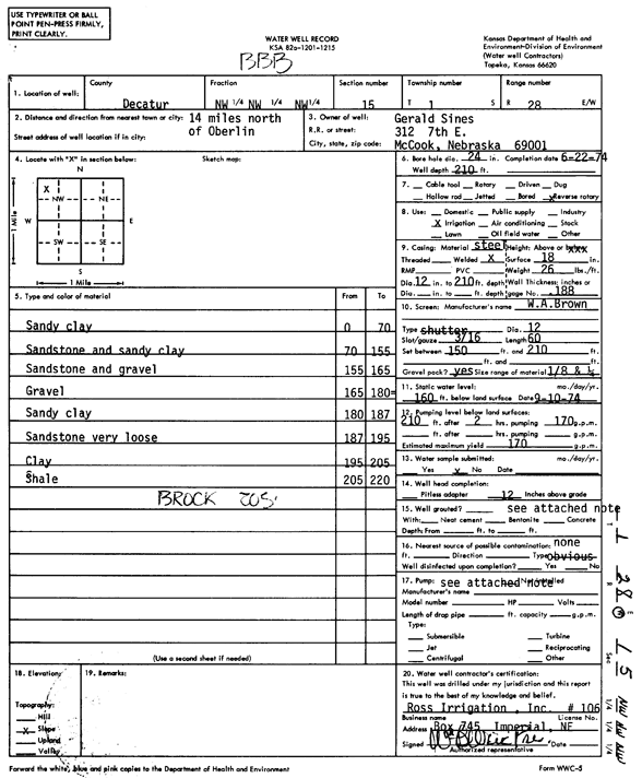
Specific Water Well Detail |
|
|
| Location Info | |||
| Owner: Sines, Gerald | Status: Constructed | ||
| Location: T1S, R28W, Sec. 15, NW NW NW | County: Decatur | ||
| Directions: from Oberlin, 14 mi N | |||
| Latitude: 39.9721433 | Longitude: -100.4577243 | Datum NAD 27 | |
| Latitude: 39.9721493 | Longitude: -100.4581474 | Datum NAD 83 | |
| Longitude and latitude calculated by Survey from township-range-section-quarter calls. Only good to within the quarter call accuracy. | |||
| View well on interactive map | |||
| General Info | ||
| Well Depth: 210 ft. | Elevation: ft. | |
| Static Water Level: 160 ft. | Est. Yield: 170 gpm. | |
| Comp. Date: 22-Jun-1974 | Well Use: Irrigation | |
| DWR Applic. #: | Other ID: | |
| Links | |
| View info from Wizard Water Level Data base... | |
| View info from WIMAS Water Right Data base... | |
| Driller Info | ||
| Driller: Mack Ross Irrigation, Inc. | License #: 106 | |
| Scanned Form | View scan |
|
Chemical Sample Submitted?: No
Water Well disinfected?: | ||
| Ground water encountered: 0 ft. , 0 ft. , 0 ft. | ||
| Pump test data: Well water was 0 ft after 0 hours pumping 0 gpm | ||
| Casing Info | ||
| Casing Type: Steel
Casing Joints: |
Diam: 12 in. to 210 ft | |
| Casing height above land surface: in
Casing Weight: lbs/ft Wall thickness or gauge no.: | ||
| Screen and Perforation Info | ||
| Screen Type: Steel | Screen Openings: | |
| Screen-perforated intervals | From: 150 ft to 210 ft | |
| Gravel pack intervals | From: ft to ft | |
| Grout Info | ||
| Grout used: | From: 0 to 0 ft
From: 0 to 0 ft From: 0 to 0 ft | |
| Source of Possible Contamination | ||
| Source: | ||
| Direction from well: | Distance: 0 ft | |
| Lithologic Log
(Log data entered by KGS.) | ||
| From: 0 ft. to 70 ft. | sandy clay | |
| From: 70 ft. to 155 ft. | sandstone and sandy clay | |
| From: 155 ft. to 165 ft. | sandstone and gravel | |
| From: 165 ft. to 180 ft. | gravel | |
| From: 180 ft. to 187 ft. | sandy clay | |
| From: 187 ft. to 195 ft. | sandstone very loose | |
| From: 195 ft. to 205 ft. | clay | |
| From: 205 ft. to 220 ft. | shale | |