|
|
|
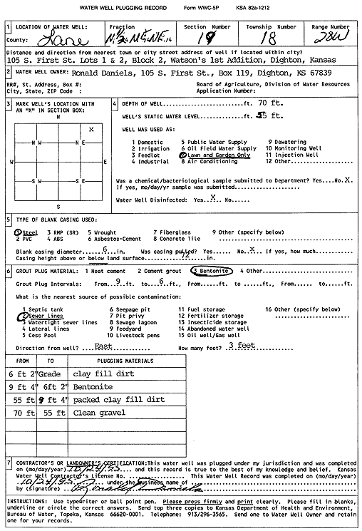
Specific Water Well Detail |
|
|
| Location Info | |||
| Owner: Daniels, Ronald | Status: Plugged | ||
| Location: T18S, R28W, Sec. 19, N2 NE NE | County: Lane | ||
| Directions: 105 S 1st St - lots 1 and 2, block 2, Watson's 1st addition, Dighton | |||
| Latitude: 38.4812566 | Longitude: -100.4509498 | Datum NAD 27 | |
| Latitude: 38.4812734 | Longitude: -100.4513671 | Datum NAD 83 | |
| Longitude and latitude calculated by Survey from township-range-section-quarter calls. Only good to within the quarter call accuracy. | |||
| View well on interactive map | |||
| General Info | ||
| Well Depth: 70 ft. | Elevation: ft. | |
| Static Water Level: 55 ft. | Est. Yield: gpm. | |
| Comp. Date: 24-Oct-1995 | Well Use: Domestic, Lawn and Garden | |
| DWR Applic. #: | Other ID: | |
| Driller Info | ||
| Driller: Ronald Daniels | License #: | |
| Scanned Form | View scan |
| Casing Info | ||
|
Casing Type: Steel
Diam: 6 in. Casing height above land surface: in | ||
| Grout Info | ||
| Grout used: Bentonite | From: 6 to 9 ft
From: 0 to 0 ft From: 0 to 0 ft | |
| Source of Possible Contamination | ||
| Source: Sewer lines | ||
| Direction from well: E | Distance: 3 ft | |