|
|
|
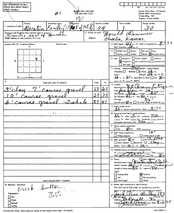
Specific Water Well Detail |
|
|
| Location Info | |||
| Owner: Demmer, Harold | Status: Constructed | ||
| Location: T1S, R30W, Sec. 34, SW SE NE | County: Decatur | ||
| Directions: from Herndon, 5 mi E | |||
| Latitude: 39.9233123 | Longitude: -100.668033 | Datum NAD 27 | |
| Latitude: 39.9233168 | Longitude: -100.6684608 | Datum NAD 83 | |
| Longitude and latitude calculated by Survey from township-range-section-quarter calls. Only good to within the quarter call accuracy. | |||
| View well on interactive map | |||
| General Info | ||
| Well Depth: 41 ft. | Elevation: ft. | |
| Static Water Level: 35 ft. | Est. Yield: 750 gpm. | |
| Comp. Date: 01-Aug-1975 | Well Use: Irrigation | |
| DWR Applic. #: | Other ID: | |
| Links | |
| No Wizard information available. | |
| View info from WIMAS Water Right Data base... | |
| Driller Info | ||
| Driller: Jack Poore Drilling Inc. | License #: 197 | |
| Scanned Form | View scan |
|
Chemical Sample Submitted?: No
Water Well disinfected?: | ||
| Ground water encountered: 0 ft. , 0 ft. , 0 ft. | ||
| Pump test data: Well water was 0 ft after 0 hours pumping 0 gpm | ||
| Casing Info | ||
| Casing Type:
Casing Joints: |
Diam: 0 in. to 0 ft
Diam: 0 in. to 0 ft Diam: 0 in. to 0 ft | |
| Casing height above land surface: in
Casing Weight: lbs/ft Wall thickness or gauge no.: | ||
| Screen and Perforation Info | ||
| Screen Type: | Screen Openings: | |
| Screen-perforated intervals | From: 21 ft to 41 ft
From: 0 ft to 0 ft From: 0 ft to 0 ft | |
| Gravel pack intervals | From: ft to ft | |
| Grout Info | ||
| Grout used: | From: 0 to 0 ft
From: 0 to 0 ft From: 0 to 0 ft | |
| Source of Possible Contamination | ||
| Source: | ||
| Direction from well: | Distance: 0 ft | |
| Lithologic Log
(Log data entered by KGS.) | ||
| From: 13 ft. to 23 ft. | 3 feet clay, 7 feet coarse gravel | |
| From: 23 ft. to 33 ft. | 10 feet coarse gravel | |
| From: 33 ft. to 41 ft. | 6 feet coarse gravel, 2 feet shale | |