|
|
|
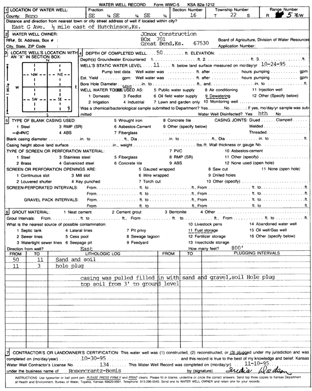
Specific Water Well Detail |
|
|
| Location Info | |||
| Owner: Jomax Construction Co. | Status: Plugged | ||
| Location: T22S, R5W, Sec. 16, SE SE SE | County: Reno | ||
| Directions: East G Ave - from Hutchinson: .5 mi E | |||
| Latitude: 38.1311597 | Longitude: -97.867743 | Datum NAD 27 | |
| Latitude: 38.1311703 | Longitude: -97.868071 | Datum NAD 83 | |
| Longitude and latitude calculated by Survey from township-range-section-quarter calls. Only good to within the quarter call accuracy. | |||
| View well on interactive map | |||
| General Info | ||
| Well Depth: 50 ft. | Elevation: ft. | |
| Static Water Level: 11 ft. | Est. Yield: gpm. | |
| Comp. Date: 30-Oct-1995 | Well Use: Dewatering | |
| DWR Applic. #: | Other ID: | |
| Driller Info | ||
| Driller: Rosencrantz-Bemis Enterprises, Inc. | License #: 134 | |
| Scanned Form | View scan |
| Casing Info | ||
|
Casing Type: PVC
Diam: 16 in. Casing height above land surface: in | ||
| Grout Info | ||
| Grout used: Bentonite | From: 3 to 11 ft
From: 0 to 0 ft From: 0 to 0 ft | |
| Source of Possible Contamination | ||
| Source: Fuel storage | ||
| Direction from well: E | Distance: 800 ft | |