|
|
|
Specific Water Well Detail |
|
|
| Location Info | |||
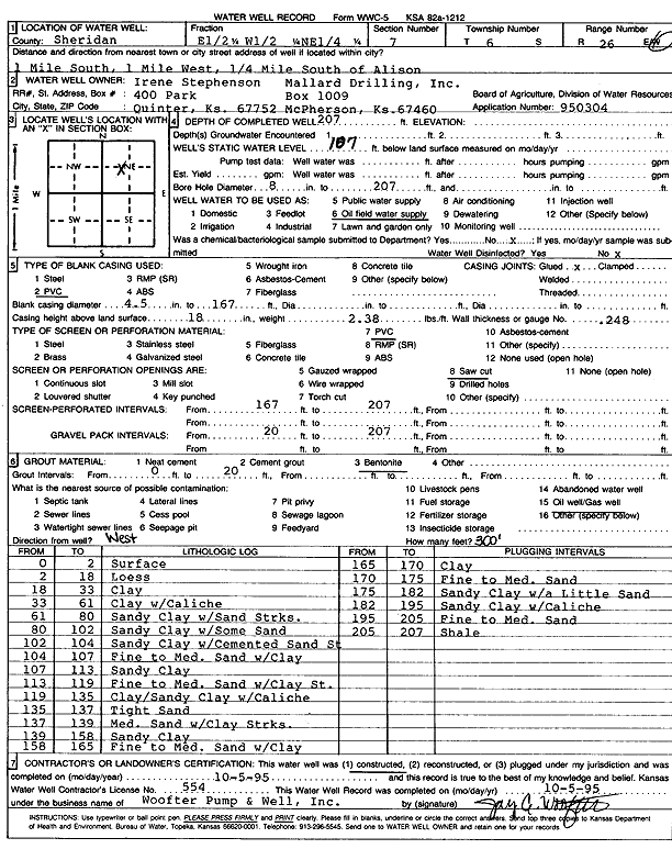
| Owner: Mallard Drilling, Inc. | Status: Constructed | ||
| Location: T6S, R26W, Sec. 7, E2 W2 NE | County: Sheridan | ||
| Directions: from Allison: 1 mi S, 1 mi W, .25 mi S | |||
| Latitude: 39.5488655 | Longitude: -100.2607689 | Datum NAD 27 | |
| Latitude: 39.548869 | Longitude: -100.2611844 | Datum NAD 83 | |
| Longitude and latitude calculated by Survey from township-range-section-quarter calls. Only good to within the quarter call accuracy. | |||
| View well on interactive map | |||
| General Info | ||
| Well Depth: 207 ft. | Elevation: ft. | |
| Static Water Level: 107 ft. | Est. Yield: gpm. | |
| Comp. Date: 05-Oct-1995 | Well Use: Oil Field Water Supply | |
| DWR Applic. #: 950304 | Other ID: | |
| Links | |
| No Wizard information available. | |
| View info from WIMAS Water Right Data base... | |
| Driller Info | ||
| Driller: Woofter Pump & Well, Inc. | License #: 554 | |
| Scanned Form | View scan |
|
Chemical Sample Submitted?: No
Water Well disinfected?: | ||
| Ground water encountered: 0 ft. , 0 ft. , 0 ft. | ||
| Pump test data: Well water was 0 ft after 0 hours pumping 0 gpm | ||
| Casing Info | ||
| Casing Type: PVC
Casing Joints: |
Diam: 4.5 in. to 167 ft
Diam: 0 in. to 0 ft Diam: 0 in. to 0 ft | |
| Casing height above land surface: in
Casing Weight: lbs/ft Wall thickness or gauge no.: | ||
| Screen and Perforation Info | ||
| Screen Type: PVC | Screen Openings: Saw cut | |
| Screen-perforated intervals | From: 167 ft to 207 ft
From: 0 ft to 0 ft From: 0 ft to 0 ft | |
| Gravel pack intervals | From: ft to ft | |
| Grout Info | ||
| Grout used: Bentonite | From: 0 to 20 ft
From: 0 to 0 ft From: 0 to 0 ft | |
| Source of Possible Contamination | ||
| Source: Oil well/gas well | ||
| Direction from well: W | Distance: 300 ft | |
| Lithologic Log
(Log data entered by KGS.) | ||
| From: 0 ft. to 2 ft. | Surface | |
| From: 2 ft. to 18 ft. | Loess | |
| From: 18 ft. to 33 ft. | Clay | |
| From: 33 ft. to 61 ft. | Clay with caliche | |
| From: 61 ft. to 80 ft. | Sandy clay with sand streaks | |
| From: 80 ft. to 102 ft. | Sandy clay with some sand | |
| From: 102 ft. to 104 ft. | Sandy clay with cemented sand streak | |
| From: 104 ft. to 107 ft. | Fine to medium sand with clay | |
| From: 107 ft. to 113 ft. | Sandy clay | |
| From: 113 ft. to 119 ft. | Fine to medium sand with clay streak | |
| From: 119 ft. to 135 ft. | Clay, sandy clay with caliche | |
| From: 135 ft. to 137 ft. | Tight sand | |
| From: 137 ft. to 139 ft. | Medium sand with clay streaks | |
| From: 139 ft. to 158 ft. | Sandy clay | |
| From: 158 ft. to 165 ft. | Fine to medium sand with clay | |
| From: 165 ft. to 170 ft. | Clay | |
| From: 170 ft. to 175 ft. | Fine to medium sand | |
| From: 175 ft. to 182 ft. | Sandy clay with a little sand | |
| From: 182 ft. to 195 ft. | Sandy clay with caliche | |
| From: 195 ft. to 205 ft. | Fine to medium sand | |
| From: 205 ft. to 207 ft. | Shale | |