|
|
|
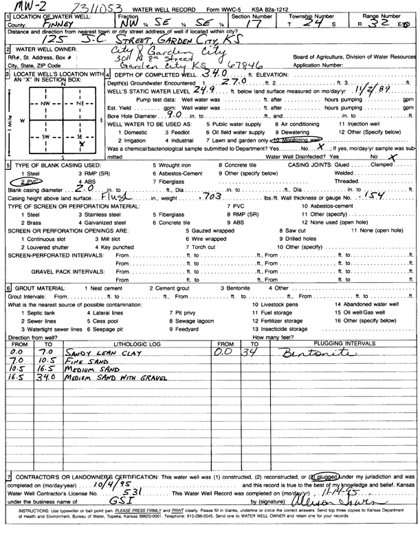
Specific Water Well Detail |
|
|
| Location Info | |||
| Owner: City of Garden City | Status: Plugged | ||
| Location: T24S, R32W, Sec. 17, NW SE SE | County: Finney | ||
| Directions: 125 JC Street | |||
| Latitude: 37.9632069 | Longitude: -100.8501311 | Datum NAD 27 | |
| Latitude: 37.9632299 | Longitude: -100.85057 | Datum NAD 83 | |
| Longitude and latitude calculated by Survey from township-range-section-quarter calls. Only good to within the quarter call accuracy. | |||
| View well on interactive map | |||
| General Info | ||
| Well Depth: 34 ft. | Elevation: ft. | |
| Static Water Level: 24.9 ft. | Est. Yield: gpm. | |
| Comp. Date: 04-Oct-1995 | Well Use: Monitoring well/observation/piezometer | |
| DWR Applic. #: | Other ID: | |
| Driller Info | ||
| Driller: Geotechnical Services, Inc. | License #: 531 | |
| Scanned Form | View scan |
| Casing Info | ||
|
Casing Type: PVC
Diam: 2 in. Casing height above land surface: in | ||
| Grout Info | ||
| Grout used: Bentonite | From: 34 to 0 ft
From: 0 to 0 ft From: 0 to 0 ft | |
| Source of Possible Contamination | ||
| Source: | ||
| Direction from well: | Distance: 0 ft | |