|
|
|
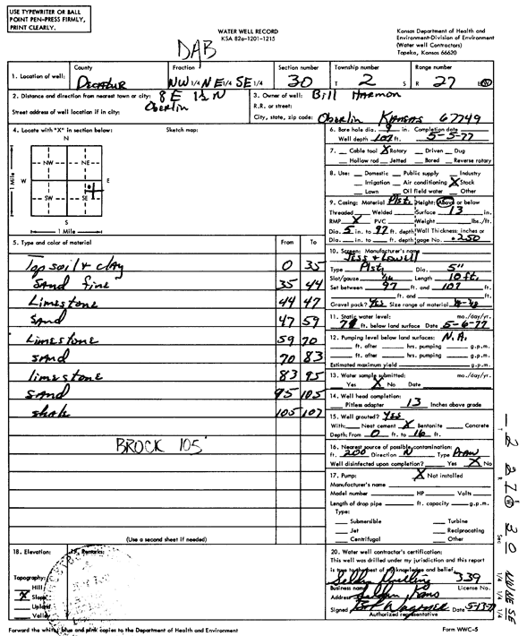
Specific Water Well Detail |
|
|
| Location Info | |||
| Owner: Harmon, Bill | Status: Constructed | ||
| Location: T2S, R27W, Sec. 30, NW NE SE | County: Decatur | ||
| Directions: from Oberlin, 8 mi E and 1.5 mi N | |||
| Latitude: 39.8489573 | Longitude: -100.3880132 | Datum NAD 27 | |
| Latitude: 39.8489625 | Longitude: -100.3884335 | Datum NAD 83 | |
| Longitude and latitude calculated by Survey from township-range-section-quarter calls. Only good to within the quarter call accuracy. | |||
| View well on interactive map | |||
| General Info | ||
| Well Depth: 107 ft. | Elevation: ft. | |
| Static Water Level: 71 ft. | Est. Yield: gpm. | |
| Comp. Date: 05-May-1977 | Well Use: Domestic, Livestock | |
| DWR Applic. #: | Other ID: | |
| Driller Info | ||
| Driller: Seldon Drilling Co., Inc. | License #: 339 | |
| Scanned Form | View scan |
|
Chemical Sample Submitted?: No
Water Well disinfected?: | ||
| Ground water encountered: 0 ft. , 0 ft. , 0 ft. | ||
| Pump test data: Well water was 0 ft after 0 hours pumping 0 gpm | ||
| Casing Info | ||
| Casing Type:
Casing Joints: |
Diam: 0 in. to 0 ft
Diam: 0 in. to 0 ft Diam: 0 in. to 0 ft | |
| Casing height above land surface: in
Casing Weight: lbs/ft Wall thickness or gauge no.: | ||
| Screen and Perforation Info | ||
| Screen Type: | Screen Openings: | |
| Screen-perforated intervals | From: 97 ft to 107 ft
From: 0 ft to 0 ft From: 0 ft to 0 ft | |
| Gravel pack intervals | From: ft to ft | |
| Grout Info | ||
| Grout used: | From: 0 to 0 ft
From: 0 to 0 ft From: 0 to 0 ft | |
| Source of Possible Contamination | ||
| Source: | ||
| Direction from well: | Distance: 0 ft | |
| Lithologic Log
(Log data entered by KGS.) | ||
| From: 0 ft. to 35 ft. | topsoil and clay | |
| From: 35 ft. to 44 ft. | sand, fine | |
| From: 44 ft. to 47 ft. | limestone | |
| From: 47 ft. to 59 ft. | sand | |
| From: 59 ft. to 70 ft. | limestone | |
| From: 70 ft. to 83 ft. | sand | |
| From: 83 ft. to 95 ft. | limestone | |
| From: 95 ft. to 105 ft. | sand | |
| From: 105 ft. to 107 ft. | shale | |