|
|
|
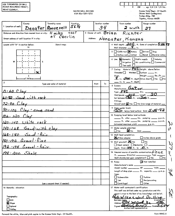
Specific Water Well Detail |
|
|
| Location Info | |||
| Owner: Richter, Brian | Status: Constructed | ||
| Location: T2S, R27W, Sec. 34, SE SE | County: Decatur | ||
| Directions: From Oberlin, 11 miles East | |||
| Latitude: 39.830035 | Longitude: -100.3309063 | Datum NAD 27 | |
| Latitude: 39.83004 | Longitude: -100.331325 | Datum NAD 83 | |
| Longitude and latitude calculated by Survey from township-range-section-quarter calls. Only good to within the quarter call accuracy. | |||
| View well on interactive map | |||
| General Info | ||
| Well Depth: 200 ft. | Elevation: ft. | |
| Static Water Level: 155 ft. | Est. Yield: gpm. | |
| Comp. Date: 05-Mar-1984 | Well Use: Domestic | |
| DWR Applic. #: | Other ID: | |
| Driller Info | ||
| Driller: Bob Wilcox Well Dilling | License #: 286 | |
| Scanned Form | View scan |
|
Chemical Sample Submitted?:
Water Well disinfected?: | ||
| Ground water encountered: 0 ft. , 0 ft. , 0 ft. | ||
| Pump test data: Well water was 0 ft after 0 hours pumping 0 gpm | ||
| Casing Info | ||
| Casing Type: PVC
Casing Joints: |
Diam: 4 in. to 200 ft
Diam: 0 in. to 0 ft Diam: 0 in. to 0 ft | |
| Casing height above land surface: in
Casing Weight: lbs/ft Wall thickness or gauge no.: | ||
| Screen and Perforation Info | ||
| Screen Type: PVC | Screen Openings: Mill slot | |
| Screen-perforated intervals | From: 180 ft to 200 ft
From: 0 ft to 0 ft From: 0 ft to 0 ft | |
| Gravel pack intervals | From: ft to ft | |
| Grout Info | ||
| Grout used: Neat cement | From: 0 to 0 ft
From: 0 to 0 ft From: 0 to 0 ft | |
| Source of Possible Contamination | ||
| Source: | ||
| Direction from well: | Distance: 0 ft | |
| Lithologic Log
(Log data entered by KGS.) | ||
| From: 0 ft. to 60 ft. | clay | |
| From: 60 ft. to 72 ft. | sand with rock | |
| From: 72 ft. to 90 ft. | clay | |
| From: 90 ft. to 106 ft. | clay, some sand | |
| From: 106 ft. to 120 ft. | clay | |
| From: 120 ft. to 140 ft. | white rock | |
| From: 140 ft. to 168 ft. | sand with rock | |
| From: 168 ft. to 180 ft. | sand, fair | |
| From: 180 ft. to 195 ft. | gravel, fine | |
| From: 195 ft. to 198 ft. | gravel, fair | |
| From: 198 ft. to 200 ft. | shale | |