|
|
|
Specific Water Well Detail |
|
|
| Location Info | |||
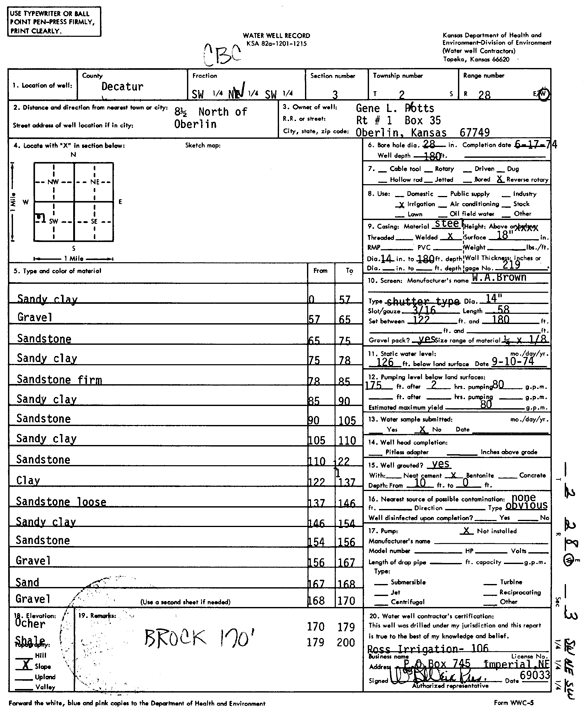
| Owner: Plotts, Gene | Status: Constructed | ||
| Location: T2S, R28W, Sec. 3, SW NE SW | County: Decatur | ||
| Directions: from Oberlin, 8.5 mi N | |||
| Latitude: 39.9051039 | Longitude: -100.4532956 | Datum NAD 27 | |
| Latitude: 39.9051096 | Longitude: -100.453718 | Datum NAD 83 | |
| Longitude and latitude calculated by Survey from township-range-section-quarter calls. Only good to within the quarter call accuracy. | |||
| View well on interactive map | |||
| General Info | ||
| Well Depth: 180 ft. | Elevation: ft. | |
| Static Water Level: 126 ft. | Est. Yield: 80 gpm. | |
| Comp. Date: 17-Jun-1974 | Well Use: Irrigation | |
| DWR Applic. #: | Other ID: | |
| Driller Info | ||
| Driller: Mack Ross Irrigation, Inc. | License #: 106 | |
| Scanned Form | View scan |
|
Chemical Sample Submitted?: No
Water Well disinfected?: | ||
| Ground water encountered: 0 ft. , 0 ft. , 0 ft. | ||
| Pump test data: Well water was 0 ft after 0 hours pumping 0 gpm | ||
| Casing Info | ||
| Casing Type:
Casing Joints: |
Diam: 0 in. to 0 ft
Diam: 0 in. to 0 ft Diam: 0 in. to 0 ft | |
| Casing height above land surface: in
Casing Weight: lbs/ft Wall thickness or gauge no.: | ||
| Screen and Perforation Info | ||
| Screen Type: | Screen Openings: | |
| Screen-perforated intervals | From: 122 ft to 180 ft
From: 0 ft to 0 ft From: 0 ft to 0 ft | |
| Gravel pack intervals | From: ft to ft | |
| Grout Info | ||
| Grout used: | From: 0 to 0 ft
From: 0 to 0 ft From: 0 to 0 ft | |
| Source of Possible Contamination | ||
| Source: | ||
| Direction from well: | Distance: 0 ft | |
| Lithologic Log
(Log data entered by KGS.) | ||
| From: 0 ft. to 57 ft. | sandy clay | |
| From: 57 ft. to 65 ft. | gravel | |
| From: 65 ft. to 75 ft. | sandstone | |
| From: 75 ft. to 78 ft. | sandy clay | |
| From: 78 ft. to 85 ft. | sandstone, firm | |
| From: 85 ft. to 90 ft. | sandy clay | |
| From: 90 ft. to 105 ft. | sandstone | |
| From: 105 ft. to 110 ft. | sandy clay | |
| From: 110 ft. to 122 ft. | sandstone | |
| From: 122 ft. to 137 ft. | clay | |
| From: 137 ft. to 146 ft. | sandstone loose | |
| From: 146 ft. to 154 ft. | sandy clay | |
| From: 154 ft. to 156 ft. | sandstone | |
| From: 156 ft. to 167 ft. | gravel | |
| From: 167 ft. to 168 ft. | sand | |
| From: 168 ft. to 170 ft. | gravel | |
| From: 170 ft. to 179 ft. | ochre | |
| From: 179 ft. to 200 ft. | shale | |