|
|
|
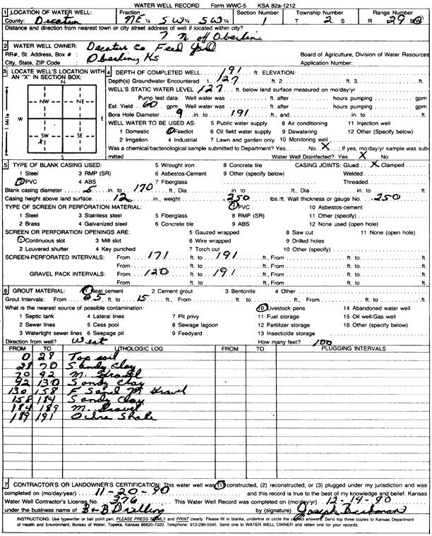
Specific Water Well Detail |
|
|
| Location Info | |||
| Owner: Decatur County Feed Yard | Status: Constructed | ||
| Location: T2S, R29W, Sec. 1, NE SW SW | County: Decatur | ||
| Directions: from Oberlin, 7 mi N | |||
| Latitude: 39.9031418 | Longitude: -100.5300558 | Datum NAD 27 | |
| Latitude: 39.9031473 | Longitude: -100.5304801 | Datum NAD 83 | |
| Longitude and latitude calculated by Survey from township-range-section-quarter calls. Only good to within the quarter call accuracy. | |||
| View well on interactive map | |||
| General Info | ||
| Well Depth: 191 ft. | Elevation: ft. | |
| Static Water Level: 127 ft. | Est. Yield: 60 gpm. | |
| Comp. Date: 20-Nov-1990 | Well Use: Feedlot | |
| DWR Applic. #: | Other ID: | |
| Driller Info | ||
| Driller: B & B Drilling | License #: 376 | |
| Scanned Form | View scan |
|
Chemical Sample Submitted?: No
Water Well disinfected?: | ||
| Ground water encountered: 127 ft. , 0 ft. , 0 ft. | ||
| Pump test data: Well water was 0 ft after 0 hours pumping 0 gpm | ||
| Casing Info | ||
| Casing Type: PVC
Casing Joints: |
Diam: 5 in. to 170 ft
Diam: 0 in. to 0 ft Diam: 0 in. to 0 ft | |
| Casing height above land surface: in
Casing Weight: lbs/ft Wall thickness or gauge no.: | ||
| Screen and Perforation Info | ||
| Screen Type: PVC | Screen Openings: Continuous slot | |
| Screen-perforated intervals | From: 171 ft to 191 ft
From: 0 ft to 0 ft From: 0 ft to 0 ft | |
| Gravel pack intervals | From: ft to ft | |
| Grout Info | ||
| Grout used: Neat cement | From: 5 to 15 ft
From: 0 to 0 ft From: 0 to 0 ft | |
| Source of Possible Contamination | ||
| Source: Livestock pens | ||
| Direction from well: | Distance: 0 ft | |
| Lithologic Log
(Log data entered by KGS.) | ||
| From: 0 ft. to 28 ft. | topsoil | |
| From: 28 ft. to 70 ft. | sandy clay | |
| From: 70 ft. to 92 ft. | medium gravel | |
| From: 92 ft. to 130 ft. | sandy clay | |
| From: 130 ft. to 158 ft. | fine sand, medium gravel | |
| From: 158 ft. to 184 ft. | sandy clay | |
| From: 184 ft. to 189 ft. | medium gravel | |
| From: 189 ft. to 191 ft. | ochre shale | |