|
|
|
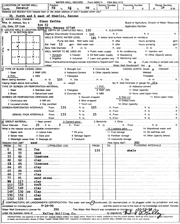
Specific Water Well Detail |
|
|
| Location Info | |||
| Owner: Kathka, Elmer | Status: Constructed | ||
| Location: T2S, R29W, Sec. 13, NE SE NW | County: Decatur | ||
| Directions: from Oberlin, 3.5 mi N and 0.25 mi E | |||
| Latitude: 39.8813967 | Longitude: -100.5255023 | Datum NAD 27 | |
| Latitude: 39.8814021 | Longitude: -100.5259262 | Datum NAD 83 | |
| Longitude and latitude calculated by Survey from township-range-section-quarter calls. Only good to within the quarter call accuracy. | |||
| View well on interactive map | |||
| General Info | ||
| Well Depth: 155 ft. | Elevation: ft. | |
| Static Water Level: 101 ft. | Est. Yield: 12 gpm. | |
| Comp. Date: 26-Sep-1990 | Well Use: Domestic | |
| DWR Applic. #: | Other ID: | |
| Driller Info | ||
| Driller: Richard O. Kelley Drilling Co. | License #: 398 | |
| Scanned Form | View scan |
|
Chemical Sample Submitted?: No
Water Well disinfected?: | ||
| Ground water encountered: 101 ft. , 0 ft. , 0 ft. | ||
| Pump test data: Well water was 0 ft after 0 hours pumping 0 gpm | ||
| Casing Info | ||
| Casing Type: PVC
Casing Joints: |
Diam: 4 in. to 105 ft
Diam: 0 in. to 0 ft Diam: 0 in. to 0 ft | |
| Casing height above land surface: in
Casing Weight: lbs/ft Wall thickness or gauge no.: | ||
| Screen and Perforation Info | ||
| Screen Type: PVC | Screen Openings: Saw cut | |
| Screen-perforated intervals | From: 105 ft to 155 ft
From: 0 ft to 0 ft From: 0 ft to 0 ft | |
| Gravel pack intervals | From: ft to ft | |
| Grout Info | ||
| Grout used: Cement grout | From: 5 to 25 ft
From: 0 to 0 ft From: 0 to 0 ft | |
| Source of Possible Contamination | ||
| Source: Livestock pens | ||
| Direction from well: | Distance: 0 ft | |
| Lithologic Log
(Log data entered by KGS.) | ||
| From: 0 ft. to 46 ft. | top | |
| From: 46 ft. to 55 ft. | sand | |
| From: 55 ft. to 60 ft. | limestone | |
| From: 60 ft. to 62 ft. | clay | |
| From: 62 ft. to 64 ft. | limestone | |
| From: 64 ft. to 65 ft. | clay | |
| From: 65 ft. to 66 ft. | rock | |
| From: 66 ft. to 77 ft. | clay | |
| From: 77 ft. to 91 ft. | sandstone | |
| From: 91 ft. to 117 ft. | clay | |
| From: 117 ft. to 118 ft. | rock | |
| From: 118 ft. to 149 ft. | clay | |
| From: 149 ft. to 150 ft. | clay | |
| From: 150 ft. to 152 ft. | clay | |
| From: 152 ft. to 155 ft. | sand | |
| From: 155 ft. to ft. | shale | |