|
|
|
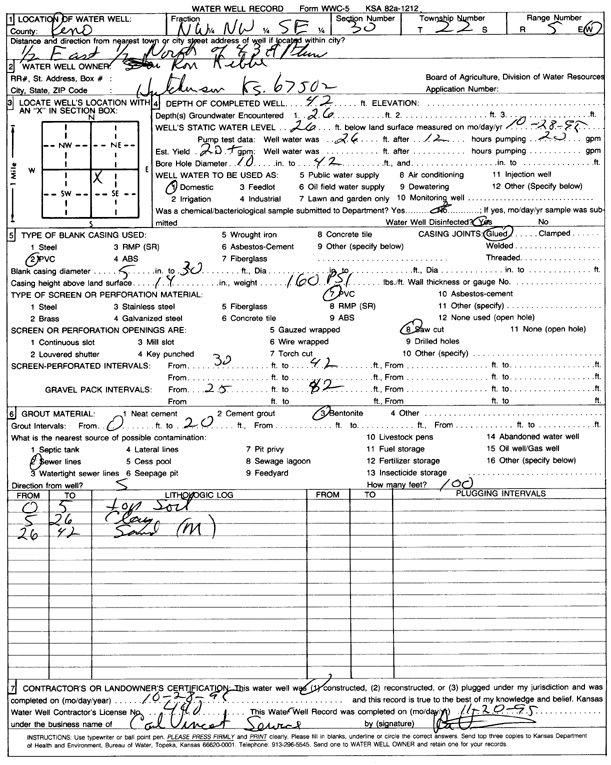
Specific Water Well Detail |
|
|
| Location Info | |||
| Owner: Kibbe, Ron | Status: Constructed | ||
| Location: T22S, R5W, Sec. 30, NW NW SE | County: Reno | ||
| Directions: from 43rd and Plum: .5 mi E, .5 mi N | |||
| Latitude: 38.1073873 | Longitude: -97.9114391 | Datum NAD 27 | |
| Latitude: 38.1073981 | Longitude: -97.9117684 | Datum NAD 83 | |
| Longitude and latitude calculated by Survey from township-range-section-quarter calls. Only good to within the quarter call accuracy. | |||
| View well on interactive map | |||
| General Info | ||
| Well Depth: 42 ft. | Elevation: ft. | |
| Static Water Level: 26 ft. | Est. Yield: 20 gpm. | |
| Comp. Date: 28-Oct-1995 | Well Use: Domestic | |
| DWR Applic. #: | Other ID: | |
| Driller Info | ||
| Driller: Carl Vincent Service | License #: 440 | |
| Scanned Form | View scan |
|
Chemical Sample Submitted?: No
Water Well disinfected?: | ||
| Ground water encountered: 26 ft. , 0 ft. , 0 ft. | ||
| Pump test data: Well water was 26 ft after 12 hours pumping 20 gpm | ||
| Casing Info | ||
| Casing Type: PVC
Casing Joints: |
Diam: 5 in. to 30 ft
Diam: 0 in. to 0 ft Diam: 0 in. to 0 ft | |
| Casing height above land surface: in
Casing Weight: lbs/ft Wall thickness or gauge no.: | ||
| Screen and Perforation Info | ||
| Screen Type: PVC | Screen Openings: Saw cut | |
| Screen-perforated intervals | From: 30 ft to 42 ft
From: 0 ft to 0 ft From: 0 ft to 0 ft | |
| Gravel pack intervals | From: ft to ft | |
| Grout Info | ||
| Grout used: Bentonite | From: 0 to 20 ft
From: 0 to 0 ft From: 0 to 0 ft | |
| Source of Possible Contamination | ||
| Source: Sewer lines | ||
| Direction from well: S | Distance: 100 ft | |
| Lithologic Log
(Log data entered by KGS.) | ||
| From: 0 ft. to 5 ft. | top soil | |
| From: 5 ft. to 26 ft. | clay | |
| From: 26 ft. to 42 ft. | sand, medium | |