|
|
|
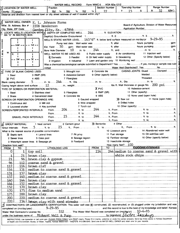
Specific Water Well Detail |
|
|
| Location Info | |||
| Owner: K.L. Johnson Farm | Status: Constructed | ||
| Location: T23S, R32W, Sec. 22, NW NW SW | County: Finney | ||
| Directions: | |||
| Latitude: 38.0391339 | Longitude: -100.8276162 | Datum NAD 27 | |
| Latitude: 38.0391563 | Longitude: -100.8280529 | Datum NAD 83 | |
| Longitude and latitude calculated by Survey from township-range-section-quarter calls. Only good to within the quarter call accuracy. | |||
| View well on interactive map | |||
| General Info | ||
| Well Depth: 244 ft. | Elevation: ft. | |
| Static Water Level: 163.6 ft. | Est. Yield: 50 gpm. | |
| Comp. Date: 28-Sep-1995 | Well Use: Domestic | |
| DWR Applic. #: | Other ID: | |
| Driller Info | ||
| Driller: Midwest Well & Pump, Inc. | License #: 532 | |
| Scanned Form | View scan |
|
Chemical Sample Submitted?: No
Water Well disinfected?: | ||
| Ground water encountered: 0 ft. , 0 ft. , 0 ft. | ||
| Pump test data: Well water was 0 ft after 0 hours pumping 0 gpm | ||
| Casing Info | ||
| Casing Type: PVC
Casing Joints: |
Diam: 5 in. to 244 ft
Diam: 0 in. to 0 ft Diam: 0 in. to 0 ft | |
| Casing height above land surface: in
Casing Weight: lbs/ft Wall thickness or gauge no.: | ||
| Screen and Perforation Info | ||
| Screen Type: PVC | Screen Openings: Saw cut | |
| Screen-perforated intervals | From: 204 ft to 244 ft
From: 0 ft to 0 ft From: 0 ft to 0 ft | |
| Gravel pack intervals | From: ft to ft | |
| Grout Info | ||
| Grout used: Bentonite | From: 5 to 25 ft
From: 0 to 0 ft From: 0 to 0 ft | |
| Source of Possible Contamination | ||
| Source: Septic Tank | ||
| Direction from well: | Distance: 100 ft | |
| Lithologic Log
(Log data entered by KGS.) | ||
| From: 0 ft. to 1 ft. | top soil | |
| From: 1 ft. to 21 ft. | brown clay | |
| From: 21 ft. to 96 ft. | brown clay and gypsum | |
| From: 96 ft. to 112 ft. | coarse sand and gravel | |
| From: 112 ft. to 116 ft. | brown clay | |
| From: 116 ft. to 131 ft. | medium to coarse sand and gravel | |
| From: 131 ft. to 137 ft. | brown clay | |
| From: 137 ft. to 140 ft. | medium to coarse sand and gravel | |
| From: 140 ft. to 144 ft. | brown clay | |
| From: 144 ft. to 152 ft. | medium to coarse sand and gravel | |
| From: 152 ft. to 170 ft. | brown clay | |
| From: 170 ft. to 175 ft. | fine to medium sand | |
| From: 175 ft. to 200 ft. | brown clay | |
| From: 200 ft. to 220 ft. | medium to coarse sand and gravel | |
| From: 220 ft. to 234 ft. | brown clay with sand streaks | |
| From: 234 ft. to 244 ft. | medium to coarse sand and gravel with white rock chips | |