|
|
|
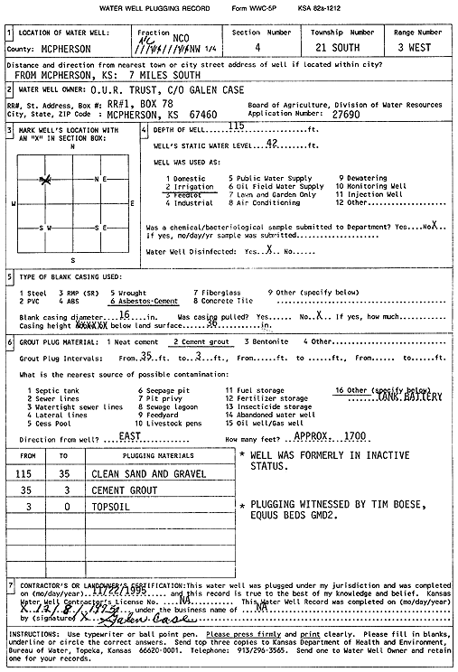
Specific Water Well Detail |
|
|
| Location Info | |||
| Owner: O.U.R Trust | Status: Plugged | ||
| Location: T21S, R3W, Sec. 4, C NW | County: McPherson | ||
| Directions: from McPherson: 7 mi S | |||
| Latitude: 38.2570753 | Longitude: -97.6609794 | Datum NAD 27 | |
| Latitude: 38.2570533 | Longitude: -97.6613011 | Datum NAD 83 | |
| Longitude and latitude calculated by Survey from township-range-section-quarter calls. Only good to within the quarter call accuracy. | |||
| View well on interactive map | |||
| General Info | ||
| Well Depth: 115 ft. | Elevation: ft. | |
| Static Water Level: 42 ft. | Est. Yield: gpm. | |
| Comp. Date: 22-Nov-1995 | Well Use: Irrigation | |
| DWR Applic. #: 27690 | Other ID: | |
| Links | |
| No Wizard information available. | |
| View info from WIMAS Water Right Data base... | |
| Driller Info | ||
| Driller: Galen Case | License #: | |
| Scanned Form | View scan |
| Casing Info | ||
|
Casing Type: ASBESTOS-CEMENT
Diam: 16 in. Casing height above land surface: in | ||
| Grout Info | ||
| Grout used: Cement grout | From: 3 to 35 ft
From: 0 to 0 ft From: 0 to 0 ft | |
| Source of Possible Contamination | ||
| Source: OTHER | ||
| Direction from well: E | Distance: 999 ft | |