|
|
|
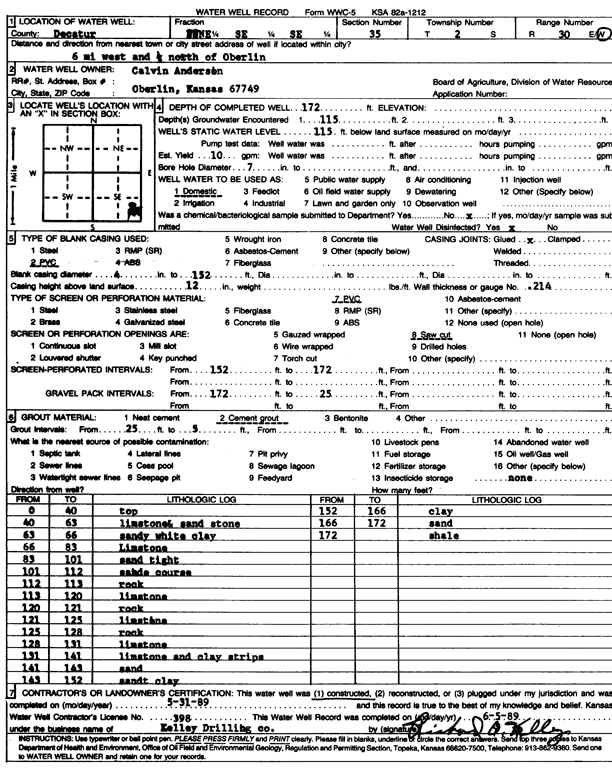
Specific Water Well Detail |
|
|
| Location Info | |||
| Owner: Anderson, Calvin | Status: Constructed | ||
| Location: T2S, R30W, Sec. 35, NE SE SE | County: Decatur | ||
| Directions: from Oberlin, 6 mi W and 0.25 mi N | |||
| Latitude: 39.8311539 | Longitude: -100.6472203 | Datum NAD 27 | |
| Latitude: 39.8311584 | Longitude: -100.6476465 | Datum NAD 83 | |
| Longitude and latitude calculated by Survey from township-range-section-quarter calls. Only good to within the quarter call accuracy. | |||
| View well on interactive map | |||
| General Info | ||
| Well Depth: 172 ft. | Elevation: ft. | |
| Static Water Level: 115 ft. | Est. Yield: 10 gpm. | |
| Comp. Date: 31-May-1989 | Well Use: Domestic | |
| DWR Applic. #: | Other ID: | |
| Driller Info | ||
| Driller: Richard O. Kelley Drilling Co. | License #: 398 | |
| Scanned Form | View scan |
|
Chemical Sample Submitted?: No
Water Well disinfected?: | ||
| Ground water encountered: 115 ft. , 0 ft. , 0 ft. | ||
| Pump test data: Well water was 0 ft after 0 hours pumping 0 gpm | ||
| Casing Info | ||
| Casing Type: PVC
Casing Joints: |
Diam: 4 in. to 152 ft
Diam: 0 in. to 0 ft Diam: 0 in. to 0 ft | |
| Casing height above land surface: in
Casing Weight: lbs/ft Wall thickness or gauge no.: | ||
| Screen and Perforation Info | ||
| Screen Type: PVC | Screen Openings: Saw cut | |
| Screen-perforated intervals | From: 152 ft to 172 ft
From: 0 ft to 0 ft From: 0 ft to 0 ft | |
| Gravel pack intervals | From: ft to ft | |
| Grout Info | ||
| Grout used: Cement grout | From: 5 to 25 ft
From: 0 to 0 ft From: 0 to 0 ft | |
| Source of Possible Contamination | ||
| Source: | ||
| Direction from well: | Distance: 0 ft | |
| Lithologic Log
(Log data entered by KGS.) | ||
| From: 0 ft. to 40 ft. | top | |
| From: 40 ft. to 63 ft. | limestone, sandstone | |
| From: 63 ft. to 66 ft. | sandy white clay | |
| From: 66 ft. to 83 ft. | limestone | |
| From: 83 ft. to 101 ft. | sand, tight | |
| From: 101 ft. to 112 ft. | sand, coarse | |
| From: 112 ft. to 113 ft. | rock | |
| From: 113 ft. to 120 ft. | limestone | |
| From: 120 ft. to 121 ft. | rock | |
| From: 121 ft. to 125 ft. | limestone | |
| From: 125 ft. to 128 ft. | rock | |
| From: 128 ft. to 131 ft. | limestone | |
| From: 131 ft. to 141 ft. | limestone and clay strips | |
| From: 141 ft. to 143 ft. | sand | |
| From: 143 ft. to 152 ft. | sandy clay | |
| From: 152 ft. to 166 ft. | clay | |
| From: 166 ft. to 172 ft. | sand | |
| From: 172 ft. to ft. | shale | |