|
|
|
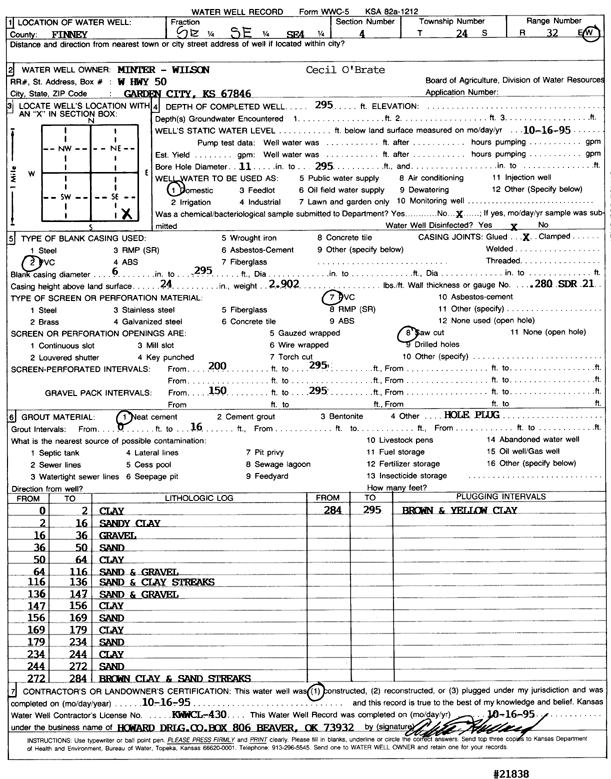
Specific Water Well Detail |
|
|
| Location Info | |||
| Owner: O'Brate, Cecil | Status: Constructed | ||
| Location: T24S, R32W, Sec. 4, SE SE SE | County: Finney | ||
| Directions: | |||
| Latitude: 37.9902173 | Longitude: -100.8295727 | Datum NAD 27 | |
| Latitude: 37.9902399 | Longitude: -100.8300105 | Datum NAD 83 | |
| Longitude and latitude calculated by Survey from township-range-section-quarter calls. Only good to within the quarter call accuracy. | |||
| View well on interactive map | |||
| General Info | ||
| Well Depth: 295 ft. | Elevation: ft. | |
| Static Water Level: ft. | Est. Yield: gpm. | |
| Comp. Date: 16-Oct-1995 | Well Use: Domestic | |
| DWR Applic. #: | Other ID: | |
| Driller Info | ||
| Driller: Howard Drilling Co. | License #: 430 | |
| Scanned Form | View scan |
|
Chemical Sample Submitted?: No
Water Well disinfected?: | ||
| Ground water encountered: 0 ft. , 0 ft. , 0 ft. | ||
| Pump test data: Well water was 0 ft after 0 hours pumping 0 gpm | ||
| Casing Info | ||
| Casing Type: PVC
Casing Joints: |
Diam: 6 in. to 0 ft
Diam: 0 in. to 0 ft Diam: 0 in. to 0 ft | |
| Casing height above land surface: in
Casing Weight: lbs/ft Wall thickness or gauge no.: | ||
| Screen and Perforation Info | ||
| Screen Type: PVC | Screen Openings: Mill slot | |
| Screen-perforated intervals | From: 200 ft to 295 ft
From: 0 ft to 0 ft From: 0 ft to 0 ft | |
| Gravel pack intervals | From: ft to ft | |
| Grout Info | ||
| Grout used: Neat cement, | From: 0 to 16 ft
From: 0 to 0 ft From: 0 to 0 ft | |
| Source of Possible Contamination | ||
| Source: | ||
| Direction from well: | Distance: 0 ft | |
| Lithologic Log
(Log data entered by KGS.) | ||
| From: 0 ft. to 2 ft. | clay | |
| From: 2 ft. to 16 ft. | sandy clay | |
| From: 16 ft. to 36 ft. | gravel | |
| From: 36 ft. to 50 ft. | sand | |
| From: 50 ft. to 64 ft. | clay | |
| From: 64 ft. to 116 ft. | sand and gravel | |
| From: 116 ft. to 136 ft. | sand and clay streaks | |
| From: 136 ft. to 147 ft. | sand and gravel | |
| From: 147 ft. to 156 ft. | clay | |
| From: 156 ft. to 169 ft. | sand | |
| From: 169 ft. to 179 ft. | clay | |
| From: 179 ft. to 234 ft. | sand | |
| From: 234 ft. to 244 ft. | clay | |
| From: 244 ft. to 272 ft. | sand | |
| From: 272 ft. to 284 ft. | brown clay and sand streaks | |
| From: 284 ft. to 295 ft. | brown and yellow clay | |