|
|
|
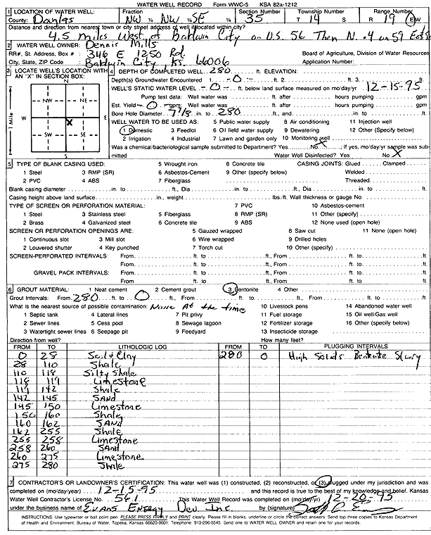
Specific Water Well Detail |
|
|
| Location Info | |||
| Owner: Mills, Dennis | Status: Plugged | ||
| Location: T14S, R19E, Sec. 35, NW NW SE | County: Douglas | ||
| Directions: from Baldwin City: 4.5 mi W on US 56, .4 mi N on 59, E side | |||
| Latitude: 38.7886628 | Longitude: -95.2682506 | Datum NAD 27 | |
| Latitude: 38.7886691 | Longitude: -95.2685019 | Datum NAD 83 | |
| Longitude and latitude calculated by Survey from township-range-section-quarter calls. Only good to within the quarter call accuracy. | |||
| View well on interactive map | |||
| General Info | ||
| Well Depth: 280 ft. | Elevation: ft. | |
| Static Water Level: ft. | Est. Yield: gpm. | |
| Comp. Date: 15-Dec-1995 | Well Use: Domestic | |
| DWR Applic. #: | Other ID: | |
| Driller Info | ||
| Driller: Evans Energy Development, Inc. | License #: 561 | |
| Scanned Form | View scan |
| Casing Info | ||
|
Casing Type:
Diam: 0 in. Casing height above land surface: in | ||
| Grout Info | ||
| Grout used: Bentonite | From: 0 to 280 ft
From: 0 to 0 ft From: 0 to 0 ft | |
| Source of Possible Contamination | ||
| Source: OTHER | ||
| Direction from well: | Distance: 0 ft | |
| Lithologic Log
(Log data entered by KGS.) | ||
| From: 0 ft. to 28 ft. | soil and clay | |
| From: 28 ft. to 110 ft. | shale | |
| From: 110 ft. to 118 ft. | silty shale | |
| From: 118 ft. to 119 ft. | limestone | |
| From: 119 ft. to 142 ft. | shale | |
| From: 142 ft. to 145 ft. | sand | |
| From: 145 ft. to 150 ft. | limestone | |
| From: 150 ft. to 160 ft. | shale | |
| From: 160 ft. to 162 ft. | sand | |
| From: 162 ft. to 255 ft. | shale | |
| From: 255 ft. to 258 ft. | limestone | |
| From: 258 ft. to 260 ft. | sand | |
| From: 260 ft. to 275 ft. | limestone | |
| From: 275 ft. to 280 ft. | shale | |