|
|
|
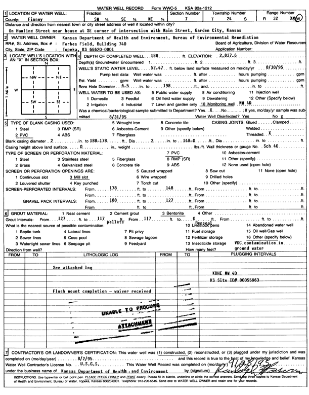
Specific Water Well Detail |
|
|
| Location Info | |||
| Owner: KDHE-BER | Status: Constructed | ||
| Location: T24S, R32W, Sec. 7, SW SE NE | County: Finney | ||
| Directions: on Hamline St near house at SE corner of jct with Main St, Garden City | |||
| Latitude: 37.9831985 | Longitude: -100.8684198 | Datum NAD 27 | |
| Latitude: 37.9832215 | Longitude: -100.8688592 | Datum NAD 83 | |
| Longitude and latitude calculated by Survey from township-range-section-quarter calls. Only good to within the quarter call accuracy. | |||
| View well on interactive map | |||
| General Info | ||
| Well Depth: 188 ft. | Elevation: 2837.6 ft. | |
| Static Water Level: 52.47 ft. | Est. Yield: gpm. | |
| Comp. Date: 02-Aug-1995 | Well Use: Monitoring well/observation/piezometer | |
| DWR Applic. #: | Other ID: MW 4D | |
| Driller Info | ||
| Driller: KDHE | License #: | |
| Scanned Form | View scan |
|
Chemical Sample Submitted?: No
Water Well disinfected?: | ||
| Ground water encountered: 0 ft. , 0 ft. , 0 ft. | ||
| Pump test data: Well water was 0 ft after 0 hours pumping 0 gpm | ||
| Casing Info | ||
| Casing Type: PVC
Casing Joints: |
Diam: 0 in. to 148 ft
Diam: 2 in. to 178 ft Diam: 2 in. to 188 ft | |
| Casing height above land surface: in
Casing Weight: lbs/ft Wall thickness or gauge no.: | ||
| Screen and Perforation Info | ||
| Screen Type: PVC | Screen Openings: Mill slot | |
| Screen-perforated intervals | From: 148 ft to 178 ft
From: 0 ft to 0 ft From: 0 ft to 0 ft | |
| Gravel pack intervals | From: ft to ft | |
| Grout Info | ||
| Grout used: Bentonite | From: 0 to 117 ft
From: 117 to 127 ft From: 0 to 0 ft | |
| Source of Possible Contamination | ||
| Source: OTHER | ||
| Direction from well: | Distance: 0 ft | |
| Lithologic Log
(log data not edited or checked by the KGS.) | ||
| From: 0 ft. to 16 ft. | Type: FINE SAND | |
| From: 16 ft. to 45 ft. | Type: SAND | |
| From: 45 ft. to 105 ft. | Type: COARSE SAND | |
| From: 105 ft. to 125 ft. | Type: SAND & GRAVEL | |
| From: 125 ft. to 170 ft. | Type: GRAVEL | |
| From: 170 ft. to 180 ft. | Type: CLAY | |
| From: 180 ft. to 185 ft. | Type: SANDY CLAY | |
| From: 185 ft. to 198 ft. | Type: CALICHE | |