|
|
|
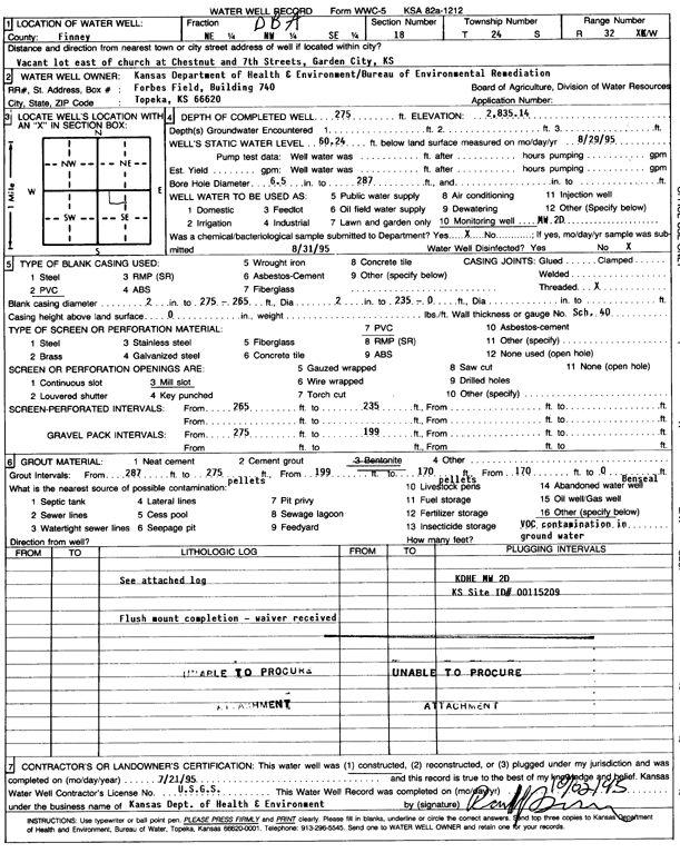
Specific Water Well Detail |
|
|
| Location Info | |||
| Owner: KDHE-BER | Status: Constructed | ||
| Location: T24S, R32W, Sec. 18, NE NW SE | County: Finney | ||
| Directions: vacant lot E of church at Chestnut and 7th St, Garden City | |||
| Latitude: 37.966857 | Longitude: -100.8705739 | Datum NAD 27 | |
| Latitude: 37.9668801 | Longitude: -100.8710135 | Datum NAD 83 | |
| Longitude and latitude calculated by Survey from township-range-section-quarter calls. Only good to within the quarter call accuracy. | |||
| View well on interactive map | |||
| General Info | ||
| Well Depth: 275 ft. | Elevation: 2835.14 ft. | |
| Static Water Level: 60.24 ft. | Est. Yield: gpm. | |
| Comp. Date: 21-Jul-1995 | Well Use: Monitoring well/observation/piezometer | |
| DWR Applic. #: | Other ID: MW 2D | |
| Driller Info | ||
| Driller: USGS | License #: | |
| Scanned Form | View scan |
|
Chemical Sample Submitted?: No
Water Well disinfected?: | ||
| Ground water encountered: 0 ft. , 0 ft. , 0 ft. | ||
| Pump test data: Well water was 0 ft after 0 hours pumping 0 gpm | ||
| Casing Info | ||
| Casing Type: PVC
Casing Joints: |
Diam: 0 in. to 235 ft
Diam: 2 in. to 265 ft Diam: 2 in. to 275 ft | |
| Casing height above land surface: in
Casing Weight: lbs/ft Wall thickness or gauge no.: | ||
| Screen and Perforation Info | ||
| Screen Type: PVC | Screen Openings: Mill slot | |
| Screen-perforated intervals | From: 235 ft to 265 ft
From: 0 ft to 0 ft From: 0 ft to 0 ft | |
| Gravel pack intervals | From: ft to ft | |
| Grout Info | ||
| Grout used: Bentonite | From: 0 to 170 ft
From: 170 to 199 ft From: 275 to 287 ft | |
| Source of Possible Contamination | ||
| Source: OTHER | ||
| Direction from well: | Distance: 0 ft | |
| Lithologic Log
(log data not edited or checked by the KGS.) | ||
| From: 0 ft. to 5 ft. | Type: SILT | |
| From: 5 ft. to 70 ft. | Type: SAND | |
| From: 70 ft. to 80 ft. | Type: GRAVEL | |
| From: 80 ft. to 142 ft. | Type: CLAY | |
| From: 142 ft. to 146 ft. | Type: MEDIUM SAND | |
| From: 146 ft. to 195 ft. | Type: SAND & GRAVEL | |
| From: 195 ft. to 206 ft. | Type: GYPSUM ROCK | |
| From: 206 ft. to 247 ft. | Type: CALICHE | |
| From: 247 ft. to 256 ft. | Type: COARSE SAND | |
| From: 256 ft. to 268 ft. | Type: VERY COARSE SAND | |
| From: 268 ft. to 276 ft. | Type: SANDY CLAY | |
| From: 276 ft. to 282 ft. | Type: LIMESTONE | |
| From: 282 ft. to 287 ft. | Type: SHALE | |