|
|
|
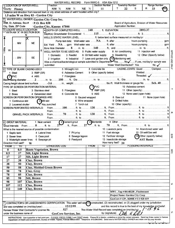
Specific Water Well Detail |
|
|
| Location Info | |||
| Owner: Garden City Coop, Inc. | Status: Constructed | ||
| Location: T22S, R33W, Sec. 11, NW NW NE | County: Finney | ||
| Directions: 1.5 mi W on HWY 83 - Garden City | |||
| Latitude: 38.1626329 | Longitude: -100.9095224 | Datum NAD 27 | |
| Latitude: 38.1626555 | Longitude: -100.9099593 | Datum NAD 83 | |
| Longitude and latitude calculated by Survey from township-range-section-quarter calls. Only good to within the quarter call accuracy. | |||
| View well on interactive map | |||
| General Info | ||
| Well Depth: 140 ft. | Elevation: 2893.37 ft. | |
| Static Water Level: ft. | Est. Yield: gpm. | |
| Comp. Date: 12-Dec-1995 | Well Use: Monitoring well/observation/piezometer | |
| DWR Applic. #: | Other ID: MW 1 | |
| Driller Info | ||
| Driller: GeoCore Services Inc. | License #: 527 | |
| Scanned Form | View scan |
|
Chemical Sample Submitted?: No
Water Well disinfected?: | ||
| Ground water encountered: 115 ft. , 0 ft. , 0 ft. | ||
| Pump test data: Well water was 0 ft after 0 hours pumping 0 gpm | ||
| Casing Info | ||
| Casing Type: PVC
Casing Joints: |
Diam: 2 in. to 100 ft
Diam: 0 in. to 0 ft Diam: 0 in. to 0 ft | |
| Casing height above land surface: in
Casing Weight: lbs/ft Wall thickness or gauge no.: | ||
| Screen and Perforation Info | ||
| Screen Type: PVC | Screen Openings: Mill slot | |
| Screen-perforated intervals | From: 100 ft to 130 ft
From: 0 ft to 0 ft From: 0 ft to 0 ft | |
| Gravel pack intervals | From: ft to ft | |
| Grout Info | ||
| Grout used: Cement grout, Bentonite | From: 0 to 27 ft
From: 27 to 70 ft From: 0 to 0 ft | |
| Source of Possible Contamination | ||
| Source: OTHER | ||
| Direction from well: W | Distance: 20 ft | |
| Lithologic Log
(Log data entered by KGS.) | ||
| From: 0 ft. to .5 ft. | roots vegetation, brown | |
| From: .5 ft. to 17 ft. | silt, light brown | |
| From: 17 ft. to 27 ft. | silt, light brown | |
| From: 27 ft. to 38 ft. | clay, brown | |
| From: 38 ft. to 50 ft. | clay, brown | |
| From: 50 ft. to 58 ft. | clay, mottled green brown | |
| From: 58 ft. to 78 ft. | clay, gray | |
| From: 78 ft. to 85 ft. | clay, brown | |
| From: 85 ft. to 98 ft. | silt, brown | |
| From: 98 ft. to 107 ft. | clay, brown | |
| From: 107 ft. to 112 ft. | clay, brown | |
| From: 112 ft. to 140 ft. | clay, brown | |