|
|
|
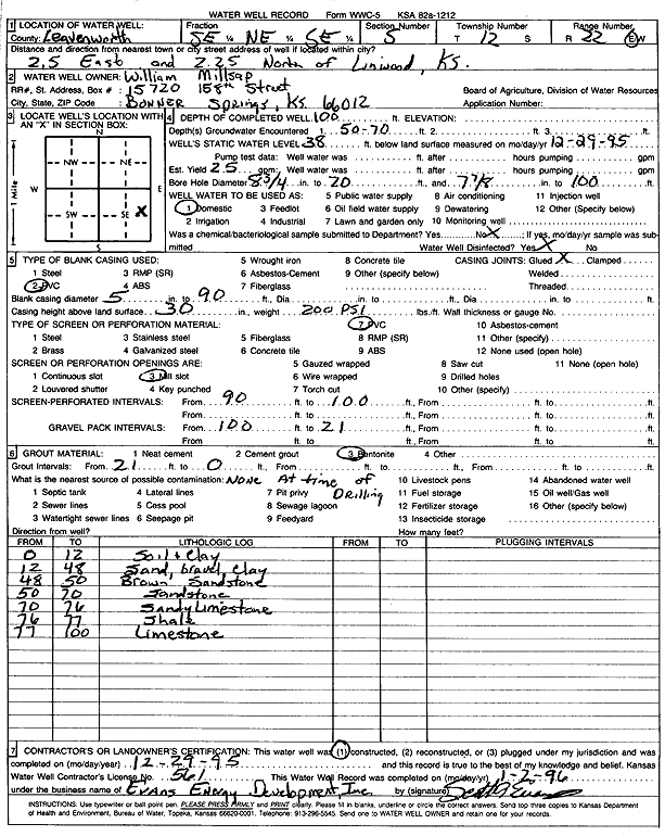
Specific Water Well Detail |
|
|
| Location Info | |||
| Owner: Millsap, William | Status: Constructed | ||
| Location: T12S, R22E, Sec. 5, SE NE SE | County: Leavenworth | ||
| Directions: from Linwood: 2.5 mi E, 2.25 mi N | |||
| Latitude: 39.0337425 | Longitude: -94.9840846 | Datum NAD 27 | |
| Latitude: 39.0337459 | Longitude: -94.9843299 | Datum NAD 83 | |
| Longitude and latitude calculated by Survey from township-range-section-quarter calls. Only good to within the quarter call accuracy. | |||
| View well on interactive map | |||
| General Info | ||
| Well Depth: 100 ft. | Elevation: ft. | |
| Static Water Level: 38 ft. | Est. Yield: 25 gpm. | |
| Comp. Date: 29-Dec-1995 | Well Use: Domestic | |
| DWR Applic. #: | Other ID: | |
| Driller Info | ||
| Driller: Evans Energy Development, Inc. | License #: 561 | |
| Scanned Form | View scan |
|
Chemical Sample Submitted?: No
Water Well disinfected?: | ||
| Ground water encountered: 70 ft. , 0 ft. , 0 ft. | ||
| Pump test data: Well water was 0 ft after 0 hours pumping 0 gpm | ||
| Casing Info | ||
| Casing Type: PVC
Casing Joints: |
Diam: 5 in. to 90 ft
Diam: 0 in. to 0 ft Diam: 0 in. to 0 ft | |
| Casing height above land surface: in
Casing Weight: lbs/ft Wall thickness or gauge no.: | ||
| Screen and Perforation Info | ||
| Screen Type: PVC | Screen Openings: Mill slot | |
| Screen-perforated intervals | From: 90 ft to 100 ft
From: 0 ft to 0 ft From: 0 ft to 0 ft | |
| Gravel pack intervals | From: ft to ft | |
| Grout Info | ||
| Grout used: Bentonite | From: 0 to 21 ft
From: 0 to 0 ft From: 0 to 0 ft | |
| Source of Possible Contamination | ||
| Source: OTHER | ||
| Direction from well: | Distance: 0 ft | |
| Lithologic Log
(Log data entered by KGS.) | ||
| From: 0 ft. to 12 ft. | soil and clay | |
| From: 12 ft. to 48 ft. | sand, gravel, and clay | |
| From: 48 ft. to 50 ft. | brown sandstone | |
| From: 50 ft. to 70 ft. | sandstone | |
| From: 70 ft. to 76 ft. | sandy limestone | |
| From: 76 ft. to 77 ft. | shale | |
| From: 77 ft. to 100 ft. | limestone | |