|
|
|
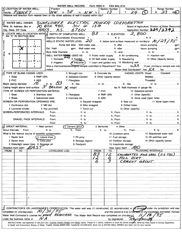
Specific Water Well Detail |
|
|
| Location Info | |||
| Owner: Sunflower Electric Power Corp. | Status: Plugged | ||
| Location: T24S, R33W, Sec. 13, NW SE NW | County: Finney | ||
| Directions: | |||
| Latitude: 37.9703344 | Longitude: -100.8954798 | Datum NAD 27 | |
| Latitude: 37.9703577 | Longitude: -100.8959204 | Datum NAD 83 | |
| Longitude and latitude calculated by Survey from township-range-section-quarter calls. Only good to within the quarter call accuracy. | |||
| View well on interactive map | |||
| General Info | ||
| Well Depth: 83 ft. | Elevation: 2800 ft. | |
| Static Water Level: 20 ft. | Est. Yield: gpm. | |
| Comp. Date: 30-Oct-1995 | Well Use: Industrial | |
| DWR Applic. #: 229 and 2342 | Other ID: | |
| Links | |
| View info from Wizard Water Level Data base... | |
| View info from WIMAS Water Right Data base... | |
| Driller Info | ||
| Driller: Ray Smith | License #: | |
| Scanned Form | View scan |
| Casing Info | ||
|
Casing Type: Steel
Diam: 16 in. Casing height above land surface: in | ||
| Grout Info | ||
| Grout used: Bentonite | From: 3 to 6 ft
From: 0 to 0 ft From: 0 to 0 ft | |
| Source of Possible Contamination | ||
| Source: Lateral lines | ||
| Direction from well: E | Distance: 180 ft | |