|
|
|
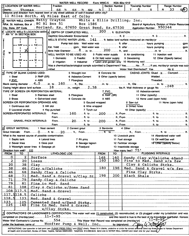
Specific Water Well Detail |
|
|
| Location Info | |||
| Owner: White and Ellis Drilling | Status: Constructed | ||
| Location: T6S, R33W, Sec. 11, SE SE NW | County: Thomas | ||
| Directions: from Colby: 11 mi N, 4.5 mi E | |||
| Latitude: 39.5474881 | Longitude: -100.971065 | Datum NAD 27 | |
| Latitude: 39.5474909 | Longitude: -100.9714969 | Datum NAD 83 | |
| Longitude and latitude calculated by Survey from township-range-section-quarter calls. Only good to within the quarter call accuracy. | |||
| View well on interactive map | |||
| General Info | ||
| Well Depth: 200 ft. | Elevation: ft. | |
| Static Water Level: 141 ft. | Est. Yield: gpm. | |
| Comp. Date: 07-Nov-1995 | Well Use: Oil Field Water Supply | |
| DWR Applic. #: 950344 | Other ID: | |
| Driller Info | ||
| Driller: Jay C. Woofter Pump & Well, Inc. | License #: 554 | |
| Scanned Form | View scan |
|
Chemical Sample Submitted?: No
Water Well disinfected?: | ||
| Ground water encountered: 0 ft. , 0 ft. , 0 ft. | ||
| Pump test data: Well water was 0 ft after 0 hours pumping 0 gpm | ||
| Casing Info | ||
| Casing Type: PVC
Casing Joints: |
Diam: 4.5 in. to 160 ft
Diam: 0 in. to 0 ft Diam: 0 in. to 0 ft | |
| Casing height above land surface: in
Casing Weight: lbs/ft Wall thickness or gauge no.: | ||
| Screen and Perforation Info | ||
| Screen Type: PVC | Screen Openings: Saw cut | |
| Screen-perforated intervals | From: 160 ft to 200 ft
From: 0 ft to 0 ft From: 0 ft to 0 ft | |
| Gravel pack intervals | From: ft to ft | |
| Grout Info | ||
| Grout used: Bentonite | From: 0 to 20 ft
From: 0 to 0 ft From: 0 to 0 ft | |
| Source of Possible Contamination | ||
| Source: Oil well/gas well | ||
| Direction from well: SE | Distance: 75 ft | |
| Lithologic Log
(Log data entered by KGS.) | ||
| From: 0 ft. to 2 ft. | Surface | |
| From: 2 ft. to 20 ft. | Loess | |
| From: 20 ft. to 38 ft. | Clay | |
| From: 38 ft. to 46 ft. | Clay with caliche | |
| From: 46 ft. to 68 ft. | Sandy clay and caliche | |
| From: 68 ft. to 71 ft. | Medium sand and gravel with clay streak | |
| From: 79 ft. to 81 ft. | Fine to medium sand | |
| From: 81 ft. to 108 ft. | Clay and caliche with some sand | |
| From: 108 ft. to 117.5 ft. | Medium sand and gravel | |
| From: 117.5 ft. to 118.5 ft. | Caliche | |
| From: 118.5 ft. to 123 ft. | Medium sand and gravel | |
| From: 123 ft. to 125 ft. | Cemented sand with sand streaks | |
| From: 125 ft. to 148 ft. | Fine to medium sand and gravel with clay streaks | |
| From: 148 ft. to 160 ft. | Sandy clay with caliche and sand | |
| From: 160 ft. to 180 ft. | Fine to medium sand with a few clay and caliche streaks | |
| From: 180 ft. to 198 ft. | Medium sand and gravel with a few fine clay streaks | |
| From: 198 ft. to 200 ft. | Black shale | |