|
|
|
Specific Water Well Detail |
|
|
| Location Info | |||
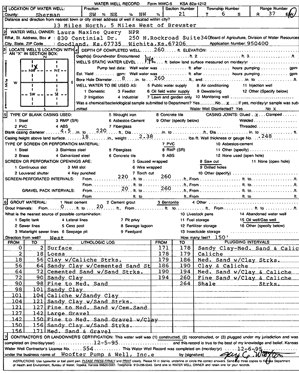
| Owner: Laura Maxine Query/NPR | Status: Constructed | ||
| Location: T6S, R37W, Sec. 21, SW NE NW | County: Sherman | ||
| Directions: From Brewster, 13 miles North and 5 miles West | |||
| Latitude: 39.5230679 | Longitude: -101.4583887 | Datum NAD 27 | |
| Latitude: 39.5230667 | Longitude: -101.4588316 | Datum NAD 83 | |
| Longitude and latitude calculated by Survey from township-range-section-quarter calls. Only good to within the quarter call accuracy. | |||
| View well on interactive map | |||
| General Info | ||
| Well Depth: 260 ft. | Elevation: ft. | |
| Static Water Level: 142 ft. | Est. Yield: gpm. | |
| Comp. Date: 05-Dec-1995 | Well Use: Oil Field Water Supply | |
| DWR Applic. #: 950400 | Other ID: | |
| Links | |
| No Wizard information available. | |
| View info from WIMAS Water Right Data base... | |
| Driller Info | ||
| Driller: Jay C. Woofter Pump & Well, Inc. | License #: 554 | |
| Scanned Form | View scan |
|
Chemical Sample Submitted?: No
Water Well disinfected?: | ||
| Ground water encountered: 0 ft. , 0 ft. , 0 ft. | ||
| Pump test data: Well water was 0 ft after 0 hours pumping 0 gpm | ||
| Casing Info | ||
| Casing Type: PVC
Casing Joints: |
Diam: 4.5 in. to 220 ft
Diam: 0 in. to 0 ft Diam: 0 in. to 0 ft | |
| Casing height above land surface: in
Casing Weight: lbs/ft Wall thickness or gauge no.: | ||
| Screen and Perforation Info | ||
| Screen Type: PVC | Screen Openings: Saw cut | |
| Screen-perforated intervals | From: 220 ft to 260 ft
From: 0 ft to 0 ft From: 0 ft to 0 ft | |
| Gravel pack intervals | From: ft to ft | |
| Grout Info | ||
| Grout used: Bentonite | From: 0 to 20 ft
From: 0 to 0 ft From: 0 to 0 ft | |
| Source of Possible Contamination | ||
| Source: Oil well/gas well | ||
| Direction from well: W | Distance: 150 ft | |
| Lithologic Log
(Log data entered by KGS.) | ||
| From: 0 ft. to 2 ft. | Surface | |
| From: 2 ft. to 18 ft. | Loess | |
| From: 18 ft. to 56 ft. | Clay with caliche streaks | |
| From: 56 ft. to 64 ft. | Sandy clay with cemented sand streaks | |
| From: 64 ft. to 72 ft. | Cemented sand with sand streaks | |
| From: 72 ft. to 90 ft. | Sandy clay | |
| From: 90 ft. to 98 ft. | Fine to medium sand | |
| From: 98 ft. to 101 ft. | Sandy clay | |
| From: 101 ft. to 104 ft. | Caliche with sandy clay | |
| From: 104 ft. to 121 ft. | Sandy clay with sand streaks | |
| From: 121 ft. to 127 ft. | Fine to medium sand with cemented sand | |
| From: 127 ft. to 142 ft. | Large gravel | |
| From: 142 ft. to 150 ft. | Fine to medium sand, gravel, with clay | |
| From: 150 ft. to 156 ft. | Sandy clay with sand streaks | |
| From: 156 ft. to 171 ft. | Medium sand and gravel | |
| From: 171 ft. to 178 ft. | Sandy clay, medium sand, and caliche | |
| From: 178 ft. to 179 ft. | Caliche | |
| From: 179 ft. to 186 ft. | Medium sand with clay streaks | |
| From: 186 ft. to 190 ft. | Clay and caliche | |
| From: 190 ft. to 194 ft. | Medium sand with clay and caliche | |
| From: 194 ft. to 260 ft. | Fine sand with clay and caliche streaks | |
| From: 260 ft. to 264 ft. | Shale | |