|
|
|
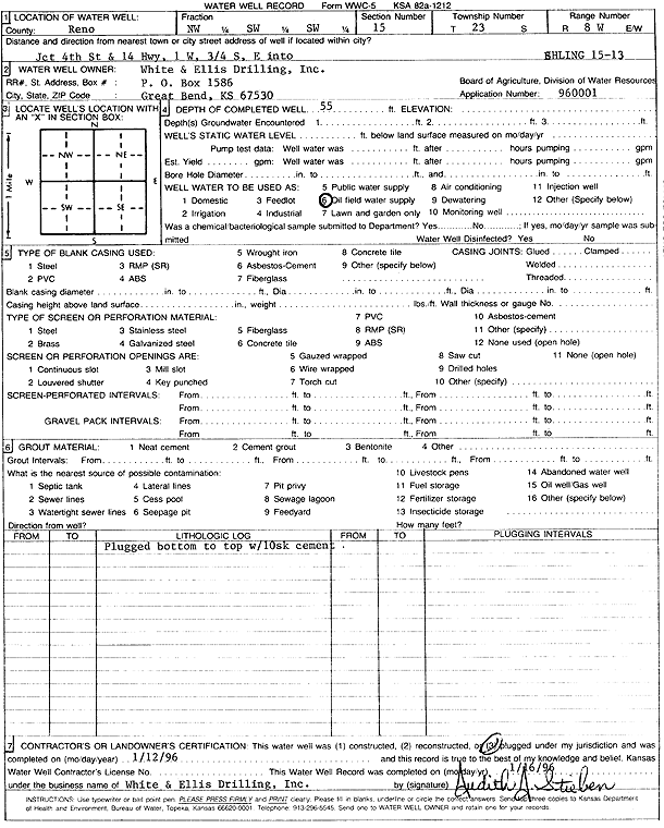
Specific Water Well Detail |
|
|
| Location Info | |||
| Owner: White and Ellis Drilling, Inc. | Status: Plugged | ||
| Location: T23S, R8W, Sec. 15, NW SW SW | County: Reno | ||
| Directions: from 4th St and Hwy 14: 1 mi W, .75 mi S, E into | |||
| Latitude: 38.045611 | Longitude: -98.195879 | Datum NAD 27 | |
| Latitude: 38.0456237 | Longitude: -98.1962192 | Datum NAD 83 | |
| Longitude and latitude calculated by Survey from township-range-section-quarter calls. Only good to within the quarter call accuracy. | |||
| View well on interactive map | |||
| General Info | ||
| Well Depth: 55 ft. | Elevation: ft. | |
| Static Water Level: ft. | Est. Yield: gpm. | |
| Comp. Date: 12-Jan-1996 | Well Use: Oil Field Water Supply | |
| DWR Applic. #: 960001 | Other ID: Ehling 15-13 | |
| Links | |
| No Wizard information available. | |
| View info from WIMAS Water Right Data base... | |
| Driller Info | ||
| Driller: White and Ellis Drilling | License #: | |
| Scanned Form | View scan |
| Casing Info | ||
|
Casing Type:
Diam: 0 in. Casing height above land surface: in | ||
| Grout Info | ||
| Grout used: Cement grout | From: 55 to 0 ft
From: 0 to 0 ft From: 0 to 0 ft | |
| Source of Possible Contamination | ||
| Source: | ||
| Direction from well: | Distance: 0 ft | |