|
|
|
Specific Water Well Detail |
|
|
| Location Info | |||
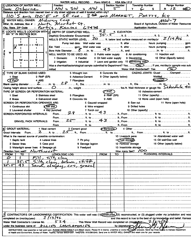
| Owner: Midway Coop | Status: Constructed | ||
| Location: T6S, R12W, Sec. 5, NW SW NW | County: Osborne | ||
| Directions: from SE corner of 3rd and Market, 110 feet S and 120 feet E, Portis | |||
| Latitude: 39.563231 | Longitude: -98.6906077 | Datum NAD 27 | |
| Latitude: 39.5632419 | Longitude: -98.6909574 | Datum NAD 83 | |
| Longitude and latitude calculated by Survey from township-range-section-quarter calls. Only good to within the quarter call accuracy. | |||
| View well on interactive map | |||
| General Info | ||
| Well Depth: 43 ft. | Elevation: ft. | |
| Static Water Level: 30 ft. | Est. Yield: gpm. | |
| Comp. Date: 13-Feb-1996 | Well Use: Monitoring well/observation/piezometer | |
| DWR Applic. #: | Other ID: MW 7 | |
| Driller Info | ||
| Driller: Professional Engineering Consultants, PA | License #: 524 | |
| Scanned Form | View scan |
|
Chemical Sample Submitted?: No
Water Well disinfected?: | ||
| Ground water encountered: 35.5 ft. , 0 ft. , 0 ft. | ||
| Pump test data: Well water was 0 ft after 0 hours pumping 0 gpm | ||
| Casing Info | ||
| Casing Type: PVC
Casing Joints: |
Diam: 2 in. to 28 ft
Diam: 0 in. to 0 ft Diam: 0 in. to 0 ft | |
| Casing height above land surface: in
Casing Weight: lbs/ft Wall thickness or gauge no.: | ||
| Screen and Perforation Info | ||
| Screen Type: PVC | Screen Openings: Mill slot | |
| Screen-perforated intervals | From: 28 ft to 43 ft
From: 0 ft to 0 ft From: 0 ft to 0 ft | |
| Gravel pack intervals | From: ft to ft | |
| Grout Info | ||
| Grout used: Bentonite | From: 2 to 25 ft
From: 0 to 0 ft From: 0 to 0 ft | |
| Source of Possible Contamination | ||
| Source: Fuel storage | ||
| Direction from well: NW | Distance: 100 ft | |
| Lithologic Log
(Log data entered by KGS.) | ||
| From: 0 ft. to 1 ft. | fill, silty clay | |
| From: 1 ft. to 35.5 ft. | silty clay, brown, stiff | |
| From: 35.5 ft. to 43 ft. | sand, clayey, coarse gravel | |