|
|
|
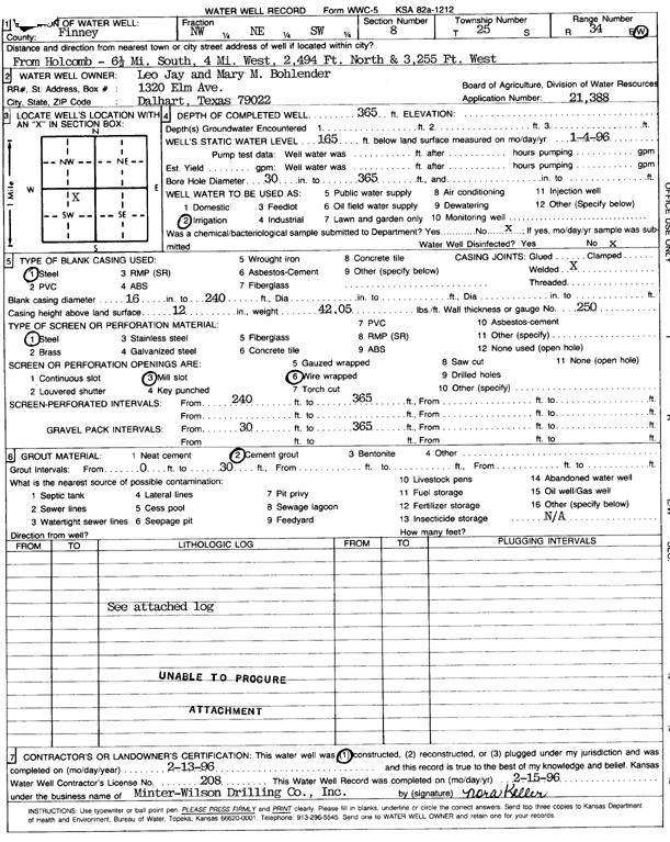
Specific Water Well Detail |
|
|
| Location Info | |||
| Owner: Bohlender, Leo Jay and Mary M. | Status: Constructed | ||
| Location: T25S, R34W, Sec. 8, NW NE SW | County: Finney | ||
| Directions: from Holcomb: 6.5 mi S, 4 mi W, 2494 feet N, and 3255 feet W | |||
| Latitude: 37.8931366 | Longitude: -101.0791657 | Datum NAD 27 | |
| Latitude: 37.8931592 | Longitude: -101.0796121 | Datum NAD 83 | |
| Longitude and latitude calculated by Survey from township-range-section-quarter calls. Only good to within the quarter call accuracy. | |||
| View well on interactive map | |||
| General Info | ||
| Well Depth: 365 ft. | Elevation: ft. | |
| Static Water Level: 165 ft. | Est. Yield: gpm. | |
| Comp. Date: 13-Feb-1996 | Well Use: Irrigation | |
| DWR Applic. #: 21388 | Other ID: | |
| Links | |
| View info from Wizard Water Level Data base... | |
| View info from WIMAS Water Right Data base... | |
| Driller Info | ||
| Driller: Minter-Wilson Drlg. Co., Inc. | License #: 208 | |
| Scanned Form | View scan |
|
Chemical Sample Submitted?: No
Water Well disinfected?: | ||
| Ground water encountered: 0 ft. , 0 ft. , 0 ft. | ||
| Pump test data: Well water was 0 ft after 0 hours pumping 0 gpm | ||
| Casing Info | ||
| Casing Type: Steel
Casing Joints: |
Diam: 16 in. to 240 ft
Diam: 0 in. to 0 ft Diam: 0 in. to 0 ft | |
| Casing height above land surface: in
Casing Weight: lbs/ft Wall thickness or gauge no.: | ||
| Screen and Perforation Info | ||
| Screen Type: Steel | Screen Openings: Mill slot | |
| Screen-perforated intervals | From: 240 ft to 365 ft
From: 0 ft to 0 ft From: 0 ft to 0 ft | |
| Gravel pack intervals | From: ft to ft | |
| Grout Info | ||
| Grout used: Cement grout | From: 0 to 30 ft
From: 0 to 0 ft From: 0 to 0 ft | |
| Source of Possible Contamination | ||
| Source: OTHER | ||
| Direction from well: | Distance: 0 ft | |
| Lithologic Log
(Log data entered by KGS.) | ||
| From: 0 ft. to 1 ft. | top soil | |
| From: 1 ft. to 270 ft. | gravel | |
| From: 270 ft. to 298 ft. | medium sand | |
| From: 298 ft. to 329 ft. | fine sand | |
| From: 329 ft. to 338 ft. | sandy clay | |
| From: 338 ft. to 357 ft. | sand and gravel | |
| From: 357 ft. to 365 ft. | sand | |