|
|
|
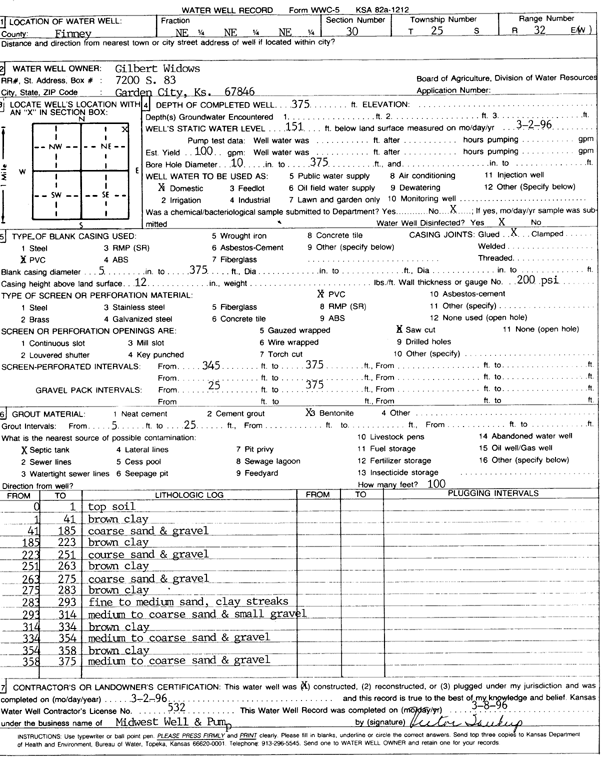
Specific Water Well Detail |
|
|
| Location Info | |||
| Owner: Widows, Gilbert | Status: Constructed | ||
| Location: T25S, R32W, Sec. 30, NE NE NE | County: Finney | ||
| Directions: | |||
| Latitude: 37.8578877 | Longitude: -100.866165 | Datum NAD 27 | |
| Latitude: 37.8579111 | Longitude: -100.8666055 | Datum NAD 83 | |
| Longitude and latitude calculated by Survey from township-range-section-quarter calls. Only good to within the quarter call accuracy. | |||
| View well on interactive map | |||
| General Info | ||
| Well Depth: 375 ft. | Elevation: ft. | |
| Static Water Level: 151 ft. | Est. Yield: 100 gpm. | |
| Comp. Date: 02-Mar-1996 | Well Use: Domestic | |
| DWR Applic. #: | Other ID: | |
| Driller Info | ||
| Driller: Midwest Well & Pump, Inc. | License #: 532 | |
| Scanned Form | View scan |
|
Chemical Sample Submitted?: No
Water Well disinfected?: | ||
| Ground water encountered: 0 ft. , 0 ft. , 0 ft. | ||
| Pump test data: Well water was 0 ft after 0 hours pumping 0 gpm | ||
| Casing Info | ||
| Casing Type: PVC
Casing Joints: |
Diam: 5 in. to 375 ft
Diam: 0 in. to 0 ft Diam: 0 in. to 0 ft | |
| Casing height above land surface: in
Casing Weight: lbs/ft Wall thickness or gauge no.: | ||
| Screen and Perforation Info | ||
| Screen Type: PVC | Screen Openings: Saw cut | |
| Screen-perforated intervals | From: 345 ft to 375 ft
From: 0 ft to 0 ft From: 0 ft to 0 ft | |
| Gravel pack intervals | From: ft to ft | |
| Grout Info | ||
| Grout used: Bentonite | From: 5 to 25 ft
From: 0 to 0 ft From: 0 to 0 ft | |
| Source of Possible Contamination | ||
| Source: Septic Tank | ||
| Direction from well: | Distance: 100 ft | |
| Lithologic Log
(Log data entered by KGS.) | ||
| From: 0 ft. to 1 ft. | top soil | |
| From: 1 ft. to 41 ft. | brown clay | |
| From: 41 ft. to 185 ft. | coarse sand and gravel | |
| From: 185 ft. to 223 ft. | brown clay | |
| From: 223 ft. to 251 ft. | coarse sand and gravel | |
| From: 251 ft. to 263 ft. | brown clay | |
| From: 263 ft. to 275 ft. | coarse sand and gravel | |
| From: 275 ft. to 283 ft. | brown clay | |
| From: 283 ft. to 293 ft. | fine to medium sand, clay streaks | |
| From: 293 ft. to 314 ft. | medium to coarse sand and small gravel | |
| From: 314 ft. to 334 ft. | brown clay | |
| From: 334 ft. to 354 ft. | medium to coarse sand and gravel | |
| From: 354 ft. to 358 ft. | brown clay | |
| From: 358 ft. to 375 ft. | medium to coarse sand and gravel | |