|
|
|
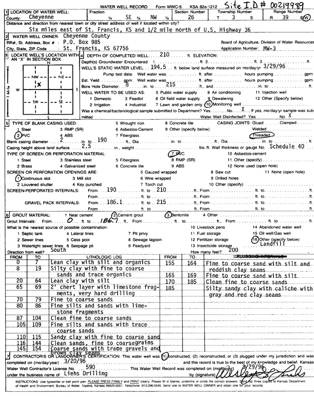
Specific Water Well Detail |
|
|
| Location Info | |||
| Owner: Cheyenne County | Status: Constructed | ||
| Location: T3S, R39W, Sec. 26, SW SE NW | County: Cheyenne | ||
| Directions: from St. Francis and US-36, 6 mi E and 0.5 mi N | |||
| Latitude: 39.7648174 | Longitude: -101.6675717 | Datum NAD 27 | |
| Latitude: 39.7648112 | Longitude: -101.6680197 | Datum NAD 83 | |
| Longitude and latitude calculated by Survey from township-range-section-quarter calls. Only good to within the quarter call accuracy. | |||
| View well on interactive map | |||
| General Info | ||
| Well Depth: 210 ft. | Elevation: ft. | |
| Static Water Level: 194.5 ft. | Est. Yield: gpm. | |
| Comp. Date: 20-Mar-1996 | Well Use: Monitoring well/observation/piezometer | |
| DWR Applic. #: | Other ID: MW 3 | |
| Driller Info | ||
| Driller: Wesley G. Liehs Drilling, Inc. | License #: 590 | |
| Scanned Form | View scan |
|
Chemical Sample Submitted?: No
Water Well disinfected?: | ||
| Ground water encountered: 0 ft. , 0 ft. , 0 ft. | ||
| Pump test data: Well water was 0 ft after 0 hours pumping 0 gpm | ||
| Casing Info | ||
| Casing Type: PVC
Casing Joints: |
Diam: 2 in. to 190 ft
Diam: 0 in. to 0 ft Diam: 0 in. to 0 ft | |
| Casing height above land surface: in
Casing Weight: lbs/ft Wall thickness or gauge no.: | ||
| Screen and Perforation Info | ||
| Screen Type: PVC | Screen Openings: Continuous slot | |
| Screen-perforated intervals | From: 190 ft to 210 ft
From: 0 ft to 0 ft From: 0 ft to 0 ft | |
| Gravel pack intervals | From: ft to ft | |
| Grout Info | ||
| Grout used: Cement grout, Bentonite | From: 0 to 186.1 ft
From: 0 to 0 ft From: 0 to 0 ft | |
| Source of Possible Contamination | ||
| Source: OTHER | ||
| Direction from well: S | Distance: 200 ft | |
| Lithologic Log
(Log data entered by KGS.) | ||
| From: 0 ft. to 7 ft. | Lean clay with silt and organics | |
| From: 8 ft. to 19 ft. | Silty clay with fine to coarse sands and trace organics | |
| From: 20 ft. to 64 ft. | Lean clay with silt | |
| From: 65 ft. to 69 ft. | 2 feet chert layer with limestone fragments, very hard drilling | |
| From: 70 ft. to 79 ft. | Fine to coarse sands | |
| From: 80 ft. to 86 ft. | Fine silts and sands with limestone fragments | |
| From: 87 ft. to 104 ft. | Clean fine to coarse sands | |
| From: 105 ft. to 109 ft. | Fine silts and sands with trace coarse sands | |
| From: 110 ft. to 115 ft. | Sandy clay with fine to coarse sand | |
| From: 116 ft. to 144 ft. | Clean sands, fine to coarse grains | |
| From: 145 ft. to 154 ft. | Coarse sands with trace gravels and brown clay seams | |
| From: 155 ft. to 164 ft. | Fine to coarse sand with silt and reddish clay seams | |
| From: 165 ft. to 169 ft. | Fine to coarse sand with silt | |
| From: 170 ft. to 185 ft. | Clean fine to coarse sands | |
| From: 185 ft. to ft. | Silty sandy clay with caliche with gray and red clay seams | |