|
|
|
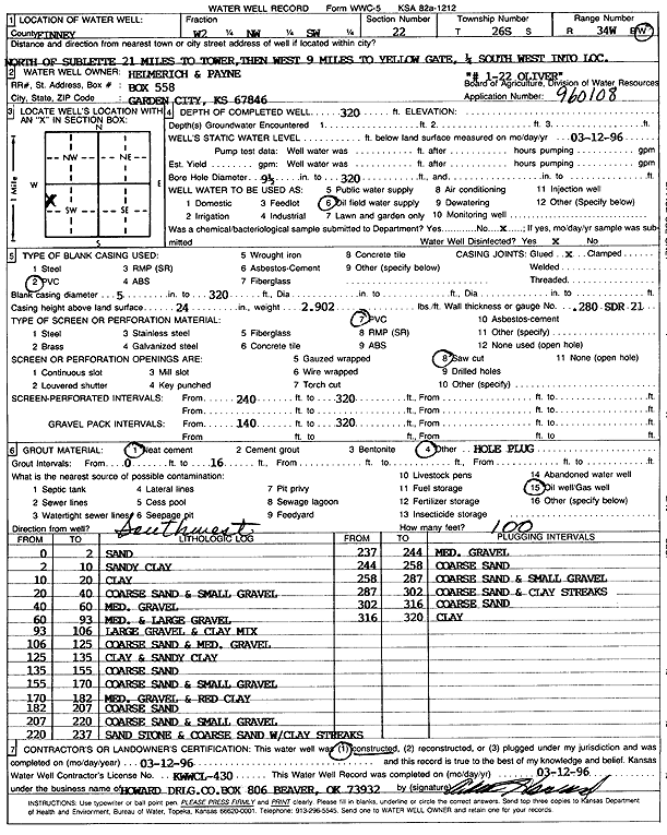
Specific Water Well Detail |
|
|
| Location Info | |||
| Owner: Helmerich and Payne Inc. | Status: Constructed | ||
| Location: T26S, R34W, Sec. 22, W2 NW SW | County: Finney | ||
| Directions: N of Sublette 21 mi to tower, 9 W to yellow gate, .25 SW into site | |||
| Latitude: 37.771221 | Longitude: -101.0336957 | Datum NAD 27 | |
| Latitude: 37.771244 | Longitude: -101.0341427 | Datum NAD 83 | |
| Longitude and latitude calculated by Survey from township-range-section-quarter calls. Only good to within the quarter call accuracy. | |||
| View well on interactive map | |||
| General Info | ||
| Well Depth: 320 ft. | Elevation: ft. | |
| Static Water Level: ft. | Est. Yield: gpm. | |
| Comp. Date: 12-Mar-1996 | Well Use: Oil Field Water Supply | |
| DWR Applic. #: 960108 | Other ID: Oliver 1-22 | |
| Links | |
| No Wizard information available. | |
| View info from WIMAS Water Right Data base... | |
| Driller Info | ||
| Driller: Howard Drilling Co. | License #: 430 | |
| Scanned Form | View scan |
|
Chemical Sample Submitted?: No
Water Well disinfected?: | ||
| Ground water encountered: 0 ft. , 0 ft. , 0 ft. | ||
| Pump test data: Well water was 0 ft after 0 hours pumping 0 gpm | ||
| Casing Info | ||
| Casing Type: PVC
Casing Joints: |
Diam: 5 in. to 320 ft
Diam: 0 in. to 0 ft Diam: 0 in. to 0 ft | |
| Casing height above land surface: in
Casing Weight: lbs/ft Wall thickness or gauge no.: | ||
| Screen and Perforation Info | ||
| Screen Type: PVC | Screen Openings: Saw cut | |
| Screen-perforated intervals | From: 240 ft to 320 ft
From: 0 ft to 0 ft From: 0 ft to 0 ft | |
| Gravel pack intervals | From: ft to ft | |
| Grout Info | ||
| Grout used: Neat cement, | From: 0 to 16 ft
From: 0 to 0 ft From: 0 to 0 ft | |
| Source of Possible Contamination | ||
| Source: Oil well/gas well | ||
| Direction from well: SW | Distance: 100 ft | |
| Lithologic Log
(Log data entered by KGS.) | ||
| From: 0 ft. to 2 ft. | sand | |
| From: 2 ft. to 10 ft. | sandy clay | |
| From: 10 ft. to 20 ft. | clay | |
| From: 20 ft. to 40 ft. | coarse sand and small gravel | |
| From: 40 ft. to 60 ft. | medium gravel | |
| From: 60 ft. to 93 ft. | med. and large gravel | |
| From: 93 ft. to 106 ft. | large gravel and clay mix | |
| From: 106 ft. to 125 ft. | coarse sand and medium gravel | |
| From: 125 ft. to 135 ft. | clay and sandy clay | |
| From: 135 ft. to 155 ft. | coarse sand | |
| From: 155 ft. to 170 ft. | coarse sand and small gravel | |
| From: 170 ft. to 182 ft. | medium gravel and red clay | |
| From: 182 ft. to 207 ft. | coarse sand | |
| From: 207 ft. to 220 ft. | coarse sand and small gravel | |
| From: 220 ft. to 237 ft. | sandstone and coarse sand with clay streaks | |
| From: 237 ft. to 244 ft. | medium gravel | |
| From: 244 ft. to 258 ft. | coarse sand | |
| From: 258 ft. to 287 ft. | coarse sand and small gravel | |
| From: 287 ft. to 302 ft. | coarse sand and clay streaks | |
| From: 302 ft. to 316 ft. | coarse sand | |
| From: 316 ft. to 320 ft. | clay | |