|
|
|
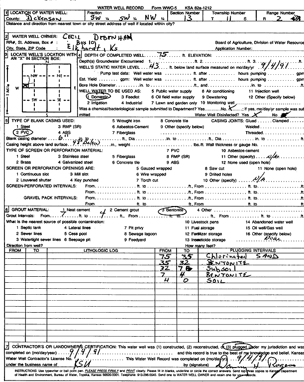
Specific Water Well Detail |
|
|
| Location Info | |||
| Owner: Debenham, Cecil | Status: Plugged | ||
| Location: T11S, R2E, Sec. 13, SW SW NW | County: Dickinson | ||
| Directions: | |||
| Latitude: 39.0982909 | Longitude: -97.1656225 | Datum NAD 27 | |
| Latitude: 39.0982875 | Longitude: -97.1659192 | Datum NAD 83 | |
| Longitude and latitude calculated by Survey from township-range-section-quarter calls. Only good to within the quarter call accuracy. | |||
| View well on interactive map | |||
| General Info | ||
| Well Depth: 75 ft. | Elevation: ft. | |
| Static Water Level: 43 ft. | Est. Yield: gpm. | |
| Comp. Date: 04-Sep-1991 | Well Use: Domestic | |
| DWR Applic. #: | Other ID: | |
| Driller Info | ||
| Driller: KSU | License #: | |
| Scanned Form | View scan |
| Casing Info | ||
|
Casing Type: PVC
Diam: 6 in. Casing height above land surface: in | ||
| Grout Info | ||
| Grout used: Bentonite | From: 4 to 7 ft
From: 0 to 0 ft From: 0 to 0 ft | |
| Source of Possible Contamination | ||
| Source: OTHER | ||
| Direction from well: | Distance: 0 ft | |