|
|
|
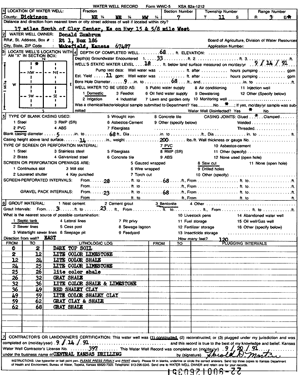
Specific Water Well Detail |
|
|
| Location Info | |||
| Owner: Zumbrum, Donald | Status: Constructed | ||
| Location: T11S, R3E, Sec. 7, NE NE NW | County: Dickinson | ||
| Directions: from Clay Center, 17 mi S on Hwy 15 and 0.6 mi W | |||
| Latitude: 39.1186278 | Longitude: -97.1403056 | Datum NAD 27 | |
| Latitude: 39.1186242 | Longitude: -97.1406017 | Datum NAD 83 | |
| Longitude and latitude calculated by Survey from township-range-section-quarter calls. Only good to within the quarter call accuracy. | |||
| View well on interactive map | |||
| General Info | ||
| Well Depth: 68 ft. | Elevation: ft. | |
| Static Water Level: 18 ft. | Est. Yield: 11 gpm. | |
| Comp. Date: 14-Sep-1991 | Well Use: Domestic | |
| DWR Applic. #: | Other ID: | |
| Driller Info | ||
| Driller: Central Kansas Drilling | License #: 397 | |
| Scanned Form | View scan |
|
Chemical Sample Submitted?: No
Water Well disinfected?: | ||
| Ground water encountered: 33 ft. , 0 ft. , 0 ft. | ||
| Pump test data: Well water was 0 ft after 0 hours pumping 0 gpm | ||
| Casing Info | ||
| Casing Type: PVC
Casing Joints: |
Diam: 5 in. to 68 ft
Diam: 0 in. to 0 ft Diam: 0 in. to 0 ft | |
| Casing height above land surface: in
Casing Weight: lbs/ft Wall thickness or gauge no.: | ||
| Screen and Perforation Info | ||
| Screen Type: PVC | Screen Openings: Saw cut | |
| Screen-perforated intervals | From: 28 ft to 68 ft
From: 0 ft to 0 ft From: 0 ft to 0 ft | |
| Gravel pack intervals | From: ft to ft | |
| Grout Info | ||
| Grout used: Bentonite | From: 3 to 23 ft
From: 0 to 0 ft From: 0 to 0 ft | |
| Source of Possible Contamination | ||
| Source: Septic Tank | ||
| Direction from well: | Distance: 0 ft | |
| Lithologic Log
(Log data entered by KGS.) | ||
| From: 0 ft. to 2 ft. | dark top soil | |
| From: 2 ft. to 12 ft. | light color limestone | |
| From: 12 ft. to 24 ft. | light color shale | |
| From: 24 ft. to 25 ft. | light color limestone | |
| From: 25 ft. to 26 ft. | light color shale | |
| From: 26 ft. to 32 ft. | gray shale | |
| From: 32 ft. to 36 ft. | light color shale and limestone | |
| From: 36 ft. to 49 ft. | red shaley clay | |
| From: 49 ft. to 59 ft. | light color shaley clay | |
| From: 59 ft. to 62 ft. | gray clay and shale | |
| From: 62 ft. to 68 ft. | gray shale | |