|
|
|
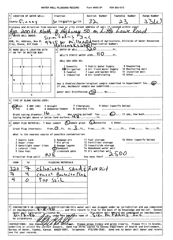
Specific Water Well Detail |
|
|
| Location Info | |||
| Owner: Six M Farms, Inc. | Status: Plugged | ||
| Location: T23S, R33W, Sec. 32, SW NW SW | County: Finney | ||
| Directions: from Hwy 50 and Little Lowe Rd, 200 feet N | |||
| Latitude: 38.0081094 | Longitude: -100.9738407 | Datum NAD 27 | |
| Latitude: 38.0081335 | Longitude: -100.9742839 | Datum NAD 83 | |
| Longitude and latitude calculated by Survey from township-range-section-quarter calls. Only good to within the quarter call accuracy. | |||
| View well on interactive map | |||
| General Info | ||
| Well Depth: 320 ft. | Elevation: ft. | |
| Static Water Level: 110 ft. | Est. Yield: gpm. | |
| Comp. Date: 08-Apr-1996 | Well Use: Irrigation | |
| DWR Applic. #: | Other ID: | |
| Links | |
| View info from Wizard Water Level Data base... | |
| View info from WIMAS Water Right Data base... | |
| Driller Info | ||
| Driller: Six M Farms, Inc. | License #: | |
| Scanned Form | View scan |
| Casing Info | ||
|
Casing Type: Steel
Diam: 16 in. Casing height above land surface: in | ||
| Grout Info | ||
| Grout used: Cement grout, Bentonite | From: 0 to 3000 ft
From: 0 to 0 ft From: 0 to 0 ft | |
| Source of Possible Contamination | ||
| Source: Feedyard | ||
| Direction from well: NE | Distance: 999 ft | |