|
|
|
Specific Water Well Detail |
|
|
| Location Info | |||
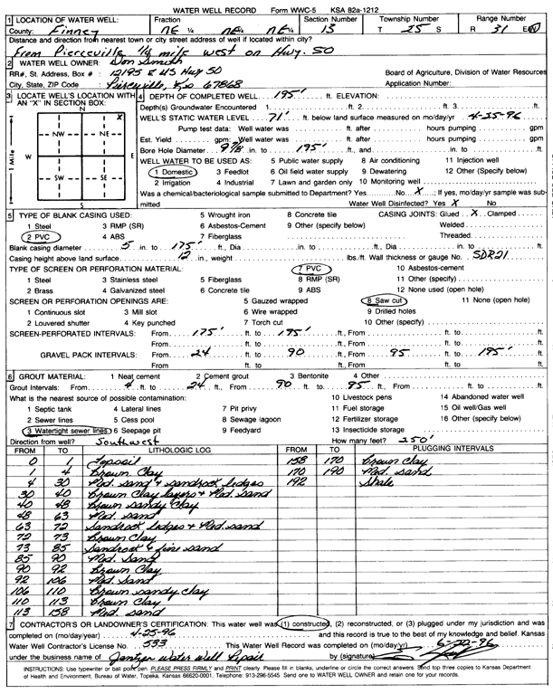
| Owner: Smith, Don | Status: Constructed | ||
| Location: T25S, R31W, Sec. 13, NE NE NE | County: Finney | ||
| Directions: from Pierceville: 0.25 mi W on Hwy 50 | |||
| Latitude: 37.8858332 | Longitude: -100.6656097 | Datum NAD 27 | |
| Latitude: 37.8858555 | Longitude: -100.6660424 | Datum NAD 83 | |
| Longitude and latitude calculated by Survey from township-range-section-quarter calls. Only good to within the quarter call accuracy. | |||
| View well on interactive map | |||
| General Info | ||
| Well Depth: 195 ft. | Elevation: ft. | |
| Static Water Level: 71 ft. | Est. Yield: gpm. | |
| Comp. Date: 25-Apr-1996 | Well Use: Domestic | |
| DWR Applic. #: | Other ID: | |
| Driller Info | ||
| Driller: Ed Jantzen Water Well Repair | License #: 533 | |
| Scanned Form | View scan |
|
Chemical Sample Submitted?: No
Water Well disinfected?: | ||
| Ground water encountered: 0 ft. , 0 ft. , 0 ft. | ||
| Pump test data: Well water was 0 ft after 0 hours pumping 0 gpm | ||
| Casing Info | ||
| Casing Type: PVC
Casing Joints: |
Diam: 5 in. to 175 ft
Diam: 0 in. to 0 ft Diam: 0 in. to 0 ft | |
| Casing height above land surface: in
Casing Weight: lbs/ft Wall thickness or gauge no.: | ||
| Screen and Perforation Info | ||
| Screen Type: PVC | Screen Openings: Saw cut | |
| Screen-perforated intervals | From: 175 ft to 195 ft
From: 0 ft to 0 ft From: 0 ft to 0 ft | |
| Gravel pack intervals | From: ft to ft | |
| Grout Info | ||
| Grout used: Cement grout, Bentonite | From: 4 to 24 ft
From: 90 to 95 ft From: 0 to 0 ft | |
| Source of Possible Contamination | ||
| Source: Watertight sewer lines | ||
| Direction from well: SW | Distance: 250 ft | |
| Lithologic Log
(Log data entered by KGS.) | ||
| From: 0 ft. to 1 ft. | topsoil | |
| From: 1 ft. to 4 ft. | brown clay | |
| From: 4 ft. to 30 ft. | medium sand and sandrock ledges | |
| From: 30 ft. to 40 ft. | brown clay layers and medium sand | |
| From: 40 ft. to 48 ft. | brown sandy clay | |
| From: 48 ft. to 63 ft. | medium sand | |
| From: 63 ft. to 72 ft. | sandrock ledges and medium sand | |
| From: 72 ft. to 73 ft. | brown clay | |
| From: 73 ft. to 85 ft. | sandrock and fine sand | |
| From: 85 ft. to 90 ft. | medium sand | |
| From: 90 ft. to 92 ft. | brown clay | |
| From: 92 ft. to 106 ft. | medium sand | |
| From: 106 ft. to 110 ft. | brown sandy clay | |
| From: 110 ft. to 113 ft. | brown clay | |
| From: 113 ft. to 158 ft. | medium sand | |
| From: 158 ft. to 170 ft. | brown clay | |
| From: 170 ft. to 190 ft. | medium sand | |
| From: 192 ft. to ft. | shale | |