|
|
|
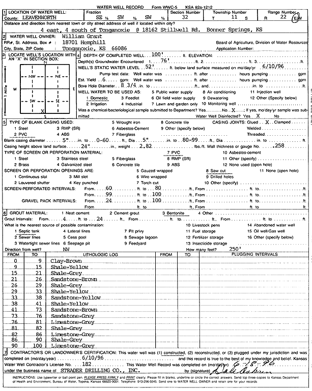
Specific Water Well Detail |
|
|
| Location Info | |||
| Owner: Grant, William | Status: Constructed | ||
| Location: T11S, R22E, Sec. 32, SE SW SW | County: Leavenworth | ||
| Directions: 18162 Stillwell Rd, Bonner Springs - from Tonganoxie: 4 mi E, 4 mi S, Bonner Springs | |||
| Latitude: 39.0447174 | Longitude: -94.9978436 | Datum NAD 27 | |
| Latitude: 39.0447206 | Longitude: -94.9980892 | Datum NAD 83 | |
| Longitude and latitude calculated by Survey from township-range-section-quarter calls. Only good to within the quarter call accuracy. | |||
| View well on interactive map | |||
| General Info | ||
| Well Depth: 100 ft. | Elevation: ft. | |
| Static Water Level: 52 ft. | Est. Yield: 6 gpm. | |
| Comp. Date: 10-Jun-1996 | Well Use: Domestic | |
| DWR Applic. #: | Other ID: | |
| Driller Info | ||
| Driller: Strader Drilling Co., Inc. | License #: 182 | |
| Scanned Form | View scan |
|
Chemical Sample Submitted?: No
Water Well disinfected?: | ||
| Ground water encountered: 76 ft. , 0 ft. , 0 ft. | ||
| Pump test data: Well water was 0 ft after 0 hours pumping 0 gpm | ||
| Casing Info | ||
| Casing Type: PVC
Casing Joints: |
Diam: 5 in. to 60 ft
Diam: 0 in. to 0 ft Diam: 0 in. to 0 ft | |
| Casing height above land surface: in
Casing Weight: lbs/ft Wall thickness or gauge no.: | ||
| Screen and Perforation Info | ||
| Screen Type: PVC | Screen Openings: Saw cut | |
| Screen-perforated intervals | From: 60 ft to 80 ft
From: 99 ft to 100 ft From: 0 ft to 0 ft | |
| Gravel pack intervals | From: ft to ft | |
| Grout Info | ||
| Grout used: Bentonite | From: 4 to 24 ft
From: 0 to 0 ft From: 0 to 0 ft | |
| Source of Possible Contamination | ||
| Source: Septic Tank | ||
| Direction from well: NW | Distance: 250 ft | |
| Lithologic Log
(Log data entered by KGS.) | ||
| From: 0 ft. to 9 ft. | clay, brown | |
| From: 9 ft. to 15 ft. | shale, yellow | |
| From: 15 ft. to 21 ft. | shale, gray | |
| From: 21 ft. to 26 ft. | sandstone, brown | |
| From: 26 ft. to 29 ft. | shale, gray | |
| From: 29 ft. to 33 ft. | shale, yellow | |
| From: 33 ft. to 38 ft. | sandstone, yellow | |
| From: 38 ft. to 41 ft. | shale, yellow | |
| From: 41 ft. to 73 ft. | sandstone, brown | |
| From: 73 ft. to 76 ft. | sandstone, gray | |
| From: 76 ft. to 81 ft. | limestone, gray | |
| From: 81 ft. to 82 ft. | shale, gray | |
| From: 82 ft. to 86 ft. | limestone, gray | |
| From: 86 ft. to 90 ft. | shale, gray | |
| From: 90 ft. to 100 ft. | limestone, gray | |