|
|
|
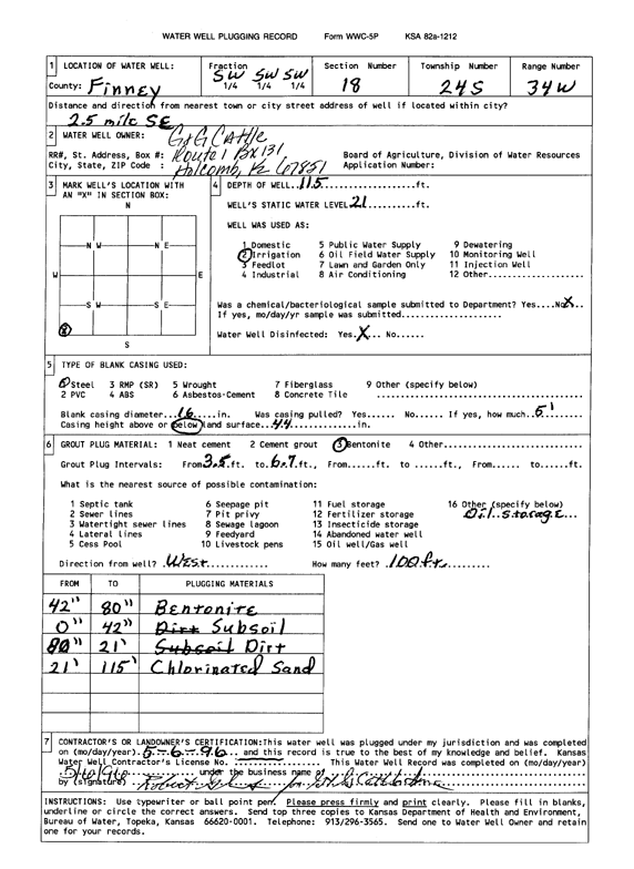
Specific Water Well Detail |
|
|
| Location Info | |||
| Owner: G&G Cattle Co. | Status: Plugged | ||
| Location: T24S, R34W, Sec. 18, SW SW SW | County: Finney | ||
| Directions: from Deerfield, 2.5 mi SE | |||
| Latitude: 37.9604494 | Longitude: -101.1014011 | Datum NAD 27 | |
| Latitude: 37.9604719 | Longitude: -101.101847 | Datum NAD 83 | |
| Longitude and latitude calculated by Survey from township-range-section-quarter calls. Only good to within the quarter call accuracy. | |||
| View well on interactive map | |||
| General Info | ||
| Well Depth: 115 ft. | Elevation: ft. | |
| Static Water Level: 21 ft. | Est. Yield: gpm. | |
| Comp. Date: 06-May-1996 | Well Use: Irrigation | |
| DWR Applic. #: | Other ID: | |
| Links | |
| View info from Wizard Water Level Data base... | |
| View info from WIMAS Water Right Data base... | |
| Driller Info | ||
| Driller: well owner | License #: | |
| Scanned Form | View scan |
| Casing Info | ||
|
Casing Type: Steel
Diam: 16 in. Casing height above land surface: in | ||
| Grout Info | ||
| Grout used: Bentonite | From: 3.5 to 6.7 ft
From: 0 to 0 ft From: 0 to 0 ft | |
| Source of Possible Contamination | ||
| Source: OTHER | ||
| Direction from well: W | Distance: 100 ft | |