|
|
|
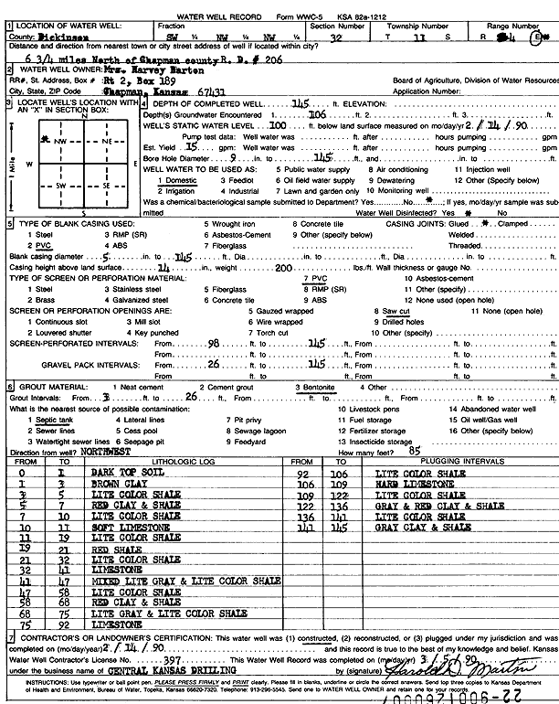
Specific Water Well Detail |
|
|
| Location Info | |||
| Owner: Barton, Mrs. Harvey | Status: Constructed | ||
| Location: T11S, R4E, Sec. 32, SW NW NW | County: Dickinson | ||
| Directions: from Chapman, 6.75 mi N, county rd 206 | |||
| Latitude: 39.0572243 | Longitude: -97.0174834 | Datum NAD 27 | |
| Latitude: 39.057222 | Longitude: -97.017775 | Datum NAD 83 | |
| Longitude and latitude calculated by Survey from township-range-section-quarter calls. Only good to within the quarter call accuracy. | |||
| View well on interactive map | |||
| General Info | ||
| Well Depth: 145 ft. | Elevation: ft. | |
| Static Water Level: 100 ft. | Est. Yield: 15 gpm. | |
| Comp. Date: 14-Feb-1990 | Well Use: Domestic | |
| DWR Applic. #: | Other ID: | |
| Driller Info | ||
| Driller: Central Kansas Drilling | License #: 397 | |
| Scanned Form | View scan |
|
Chemical Sample Submitted?: No
Water Well disinfected?: | ||
| Ground water encountered: 106 ft. , 0 ft. , 0 ft. | ||
| Pump test data: Well water was 0 ft after 0 hours pumping 0 gpm | ||
| Casing Info | ||
| Casing Type: PVC
Casing Joints: |
Diam: 5 in. to 145 ft
Diam: 0 in. to 0 ft Diam: 0 in. to 0 ft | |
| Casing height above land surface: in
Casing Weight: lbs/ft Wall thickness or gauge no.: | ||
| Screen and Perforation Info | ||
| Screen Type: PVC | Screen Openings: Saw cut | |
| Screen-perforated intervals | From: 98 ft to 145 ft
From: 0 ft to 0 ft From: 0 ft to 0 ft | |
| Gravel pack intervals | From: ft to ft | |
| Grout Info | ||
| Grout used: Bentonite | From: 3 to 26 ft
From: 0 to 0 ft From: 0 to 0 ft | |
| Source of Possible Contamination | ||
| Source: Septic Tank | ||
| Direction from well: | Distance: 0 ft | |
| Lithologic Log
(Log data entered by KGS.) | ||
| From: 0 ft. to 1 ft. | dark top soil | |
| From: 1 ft. to 3 ft. | brown clay | |
| From: 3 ft. to 5 ft. | light color shale | |
| From: 5 ft. to 7 ft. | red clay and shale | |
| From: 7 ft. to 10 ft. | light color shale | |
| From: 10 ft. to 11 ft. | soft limestone | |
| From: 11 ft. to 19 ft. | light color shale | |
| From: 19 ft. to 21 ft. | red shale | |
| From: 21 ft. to 32 ft. | light color shale | |
| From: 32 ft. to 41 ft. | limestone | |
| From: 41 ft. to 47 ft. | mixed light gray and light color shale | |
| From: 47 ft. to 58 ft. | light color shale | |
| From: 58 ft. to 68 ft. | red clay and shale | |
| From: 68 ft. to 75 ft. | light gray and light color shale | |
| From: 75 ft. to 92 ft. | limestone | |
| From: 92 ft. to 106 ft. | light color shale | |
| From: 106 ft. to 109 ft. | hard limestone | |
| From: 109 ft. to 122 ft. | light color shale | |
| From: 122 ft. to 136 ft. | gray and red clay and shale | |
| From: 136 ft. to 141 ft. | light color shale | |
| From: 141 ft. to 145 ft. | gray clay and shale | |