|
|
|
Specific Water Well Detail |
|
|
| Location Info | |||
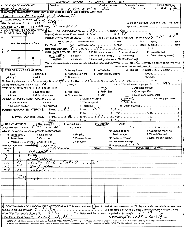
| Owner: Carron, Steve | Status: Constructed | ||
| Location: T14S, R20E, Sec. 32, NW NW | County: Douglas | ||
| Directions: from Baldwin: 1 mi W, 1 mi N | |||
| Latitude: 38.7951768 | Longitude: -95.2211407 | Datum NAD 27 | |
| Latitude: 38.7951833 | Longitude: -95.2213908 | Datum NAD 83 | |
| Longitude and latitude calculated by Survey from township-range-section-quarter calls. Only good to within the quarter call accuracy. | |||
| View well on interactive map | |||
| General Info | ||
| Well Depth: 130 ft. | Elevation: ft. | |
| Static Water Level: 20 ft. | Est. Yield: 5 gpm. | |
| Comp. Date: 15-Jul-1996 | Well Use: Domestic | |
| DWR Applic. #: | Other ID: | |
| Driller Info | ||
| Driller: Kenneth Schutz Drilling | License #: 212 | |
| Scanned Form | View scan |
|
Chemical Sample Submitted?: No
Water Well disinfected?: | ||
| Ground water encountered: 40 ft. , 93 ft. , 0 ft. | ||
| Pump test data: Well water was 0 ft after 0 hours pumping 0 gpm | ||
| Casing Info | ||
| Casing Type: PVC
Casing Joints: |
Diam: 5 in. to 65 ft
Diam: 0 in. to 0 ft Diam: 0 in. to 0 ft | |
| Casing height above land surface: in
Casing Weight: lbs/ft Wall thickness or gauge no.: | ||
| Screen and Perforation Info | ||
| Screen Type: PVC | Screen Openings: Saw cut | |
| Screen-perforated intervals | From: 65 ft to 115 ft
From: 0 ft to 0 ft From: 0 ft to 0 ft | |
| Gravel pack intervals | From: ft to ft | |
| Grout Info | ||
| Grout used: Neat cement, Bentonite | From: 5 to 25 ft
From: 0 to 0 ft From: 0 to 0 ft | |
| Source of Possible Contamination | ||
| Source: Septic Tank | ||
| Direction from well: S | Distance: 100 ft | |
| Lithologic Log
(Log data entered by KGS.) | ||
| From: 0 ft. to 4 ft. | top soil | |
| From: 4 ft. to 8 ft. | clay | |
| From: 8 ft. to 12 ft. | sandstone | |
| From: 12 ft. to 93 ft. | sandy shale, streaked | |
| From: 93 ft. to 99 ft. | limestone | |
| From: 99 ft. to 130 ft. | shale | |