|
|
|
Specific Water Well Detail |
|
|
| Location Info | |||
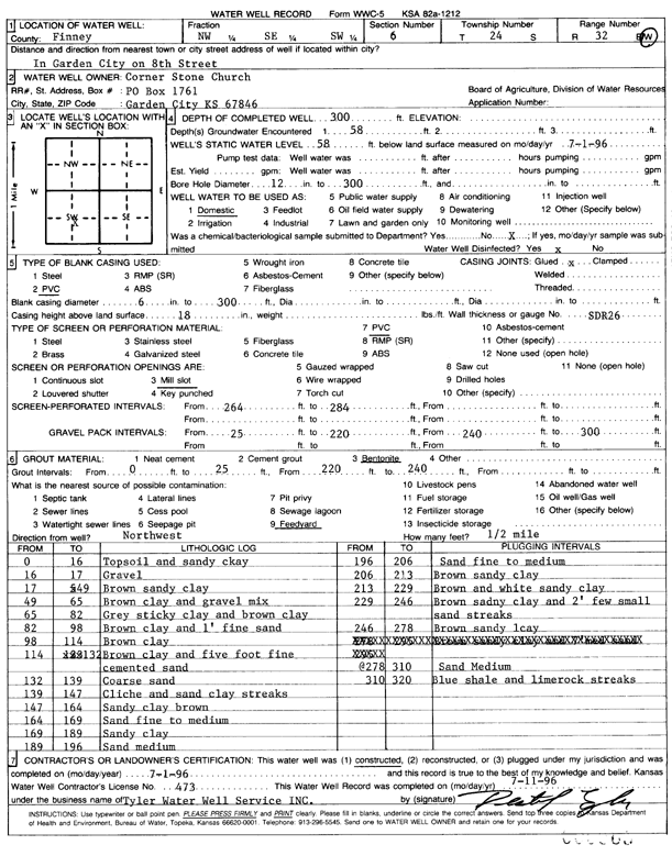
| Owner: Corner Stone Church | Status: Constructed | ||
| Location: T24S, R32W, Sec. 6, NW SE SW | County: Finney | ||
| Directions: 8th St, Garden City | |||
| Latitude: 37.9922287 | Longitude: -100.8773976 | Datum NAD 27 | |
| Latitude: 37.9922517 | Longitude: -100.8778373 | Datum NAD 83 | |
| Longitude and latitude calculated by Survey from township-range-section-quarter calls. Only good to within the quarter call accuracy. | |||
| View well on interactive map | |||
| General Info | ||
| Well Depth: 300 ft. | Elevation: ft. | |
| Static Water Level: 58 ft. | Est. Yield: gpm. | |
| Comp. Date: 01-Jul-1996 | Well Use: Domestic | |
| DWR Applic. #: | Other ID: | |
| Driller Info | ||
| Driller: Tyler Water Well | License #: 473 | |
| Scanned Form | View scan |
|
Chemical Sample Submitted?: No
Water Well disinfected?: | ||
| Ground water encountered: 58 ft. , 0 ft. , 0 ft. | ||
| Pump test data: Well water was 0 ft after 0 hours pumping 0 gpm | ||
| Casing Info | ||
| Casing Type: PVC
Casing Joints: |
Diam: 6 in. to 300 ft
Diam: 0 in. to 0 ft Diam: 0 in. to 0 ft | |
| Casing height above land surface: in
Casing Weight: lbs/ft Wall thickness or gauge no.: | ||
| Screen and Perforation Info | ||
| Screen Type: PVC | Screen Openings: Mill slot | |
| Screen-perforated intervals | From: 264 ft to 284 ft
From: 0 ft to 0 ft From: 0 ft to 0 ft | |
| Gravel pack intervals | From: ft to ft | |
| Grout Info | ||
| Grout used: Bentonite | From: 0 to 25 ft
From: 220 to 240 ft From: 0 to 0 ft | |
| Source of Possible Contamination | ||
| Source: Feedyard | ||
| Direction from well: NW | Distance: 0 ft | |
| Lithologic Log
(Log data entered by KGS.) | ||
| From: 0 ft. to 16 ft. | top soil and sandy clay | |
| From: 16 ft. to 17 ft. | gravel | |
| From: 17 ft. to 49 ft. | brown sandy clay | |
| From: 49 ft. to 65 ft. | brown clay and gravel mix | |
| From: 65 ft. to 82 ft. | gray sticky clay and brown clay | |
| From: 82 ft. to 98 ft. | brown clay and 1-foot fine sand | |
| From: 98 ft. to 114 ft. | brown clay | |
| From: 114 ft. to 132 ft. | brown clay and five foot fine cemented sand | |
| From: 132 ft. to 139 ft. | coarse sand | |
| From: 139 ft. to 147 ft. | caliche and sand clay streaks | |
| From: 147 ft. to 164 ft. | sandy clay brown | |
| From: 164 ft. to 169 ft. | sand fine to medium | |
| From: 169 ft. to 189 ft. | sandy clay | |
| From: 189 ft. to 196 ft. | sand medium | |
| From: 196 ft. to 206 ft. | sand fine to medium | |
| From: 206 ft. to 213 ft. | brown sandy clay | |
| From: 213 ft. to 229 ft. | brown and white sandy clay | |
| From: 229 ft. to 246 ft. | brown sandy clay and 2-foot few small sand streaks | |
| From: 246 ft. to 278 ft. | brown sandy clay | |
| From: 278 ft. to 310 ft. | sand medium | |
| From: 310 ft. to 320 ft. | blue shale and lime rock streaks | |