|
|
|
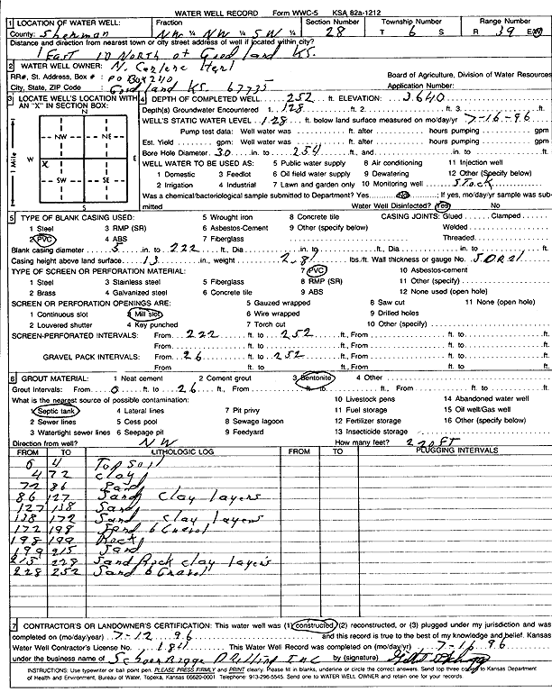
Specific Water Well Detail |
|
|
| Location Info | |||
| Owner: Herl, Carlene | Status: Constructed | ||
| Location: T6S, R39W, Sec. 28, NW NW SW | County: Sherman | ||
| Directions: From Goodland, 1 mile East and 10 miles North | |||
| Latitude: 39.5025114 | Longitude: -101.6868097 | Datum NAD 27 | |
| Latitude: 39.5025082 | Longitude: -101.6872592 | Datum NAD 83 | |
| Longitude and latitude calculated by Survey from township-range-section-quarter calls. Only good to within the quarter call accuracy. | |||
| View well on interactive map | |||
| General Info | ||
| Well Depth: 252 ft. | Elevation: 3640 ft. | |
| Static Water Level: 128 ft. | Est. Yield: gpm. | |
| Comp. Date: 12-Jul-1996 | Well Use: Domestic, Livestock | |
| DWR Applic. #: | Other ID: | |
| Driller Info | ||
| Driller: Schoenrogge Drilling, Inc. | License #: 184 | |
| Scanned Form | View scan |
|
Chemical Sample Submitted?: No
Water Well disinfected?: | ||
| Ground water encountered: 128 ft. , 0 ft. , 0 ft. | ||
| Pump test data: Well water was 0 ft after 0 hours pumping 0 gpm | ||
| Casing Info | ||
| Casing Type: PVC
Casing Joints: |
Diam: 5 in. to 222 ft
Diam: 0 in. to 0 ft Diam: 0 in. to 0 ft | |
| Casing height above land surface: in
Casing Weight: lbs/ft Wall thickness or gauge no.: | ||
| Screen and Perforation Info | ||
| Screen Type: PVC | Screen Openings: Mill slot | |
| Screen-perforated intervals | From: 222 ft to 252 ft
From: 0 ft to 0 ft From: 0 ft to 0 ft | |
| Gravel pack intervals | From: ft to ft | |
| Grout Info | ||
| Grout used: Bentonite | From: 0 to 26 ft
From: 0 to 0 ft From: 0 to 0 ft | |
| Source of Possible Contamination | ||
| Source: Septic Tank | ||
| Direction from well: NW | Distance: 220 ft | |
| Lithologic Log
(Log data entered by KGS.) | ||
| From: 0 ft. to 4 ft. | Top soil | |
| From: 4 ft. to 72 ft. | Clay | |
| From: 72 ft. to 86 ft. | Sand | |
| From: 86 ft. to 127 ft. | Sand, clay layers | |
| From: 127 ft. to 138 ft. | Sand | |
| From: 138 ft. to 172 ft. | Sand, clay layers | |
| From: 172 ft. to 198 ft. | Sand and gravel | |
| From: 198 ft. to 199 ft. | Rock | |
| From: 199 ft. to 215 ft. | Sand | |
| From: 215 ft. to 228 ft. | Sand, rock, clay layers | |
| From: 228 ft. to 252 ft. | Sand and gravel | |