|
|
|
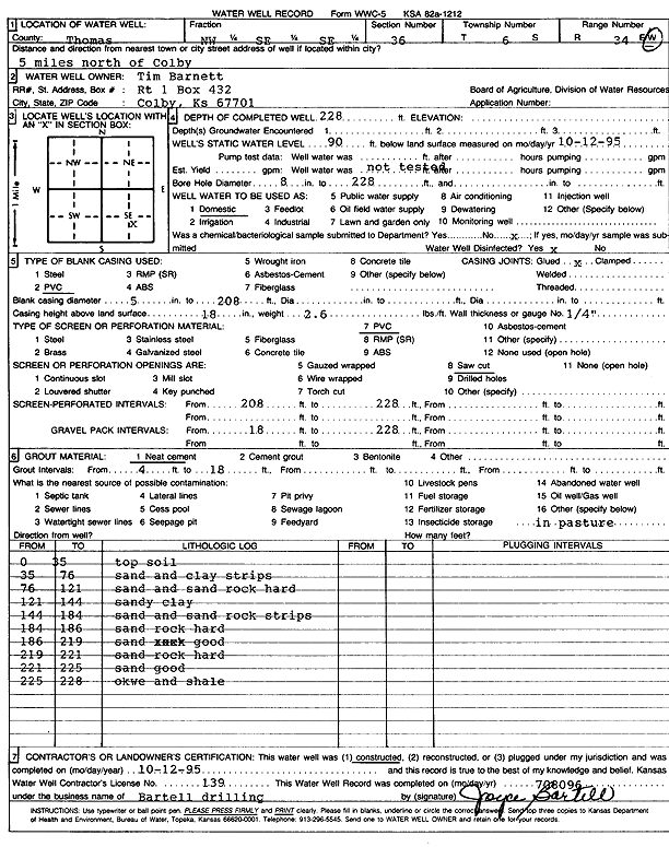
Specific Water Well Detail |
|
|
| Location Info | |||
| Owner: Barnett, Tim | Status: Constructed | ||
| Location: T6S, R34W, Sec. 36, NW SE SE | County: Thomas | ||
| Directions: from Colby: 5 mi N | |||
| Latitude: 39.4839613 | Longitude: -101.0573027 | Datum NAD 27 | |
| Latitude: 39.4839638 | Longitude: -101.0577364 | Datum NAD 83 | |
| Longitude and latitude calculated by Survey from township-range-section-quarter calls. Only good to within the quarter call accuracy. | |||
| View well on interactive map | |||
| General Info | ||
| Well Depth: 228 ft. | Elevation: ft. | |
| Static Water Level: 90 ft. | Est. Yield: gpm. | |
| Comp. Date: 12-Oct-1995 | Well Use: Domestic | |
| DWR Applic. #: | Other ID: | |
| Driller Info | ||
| Driller: Robert Bartell Drilling & Machine Works | License #: 139 | |
| Scanned Form | View scan |
|
Chemical Sample Submitted?: No
Water Well disinfected?: | ||
| Ground water encountered: 0 ft. , 0 ft. , 0 ft. | ||
| Pump test data: Well water was 0 ft after 0 hours pumping 0 gpm | ||
| Casing Info | ||
| Casing Type: PVC
Casing Joints: |
Diam: 5 in. to 208 ft
Diam: 0 in. to 0 ft Diam: 0 in. to 0 ft | |
| Casing height above land surface: in
Casing Weight: lbs/ft Wall thickness or gauge no.: | ||
| Screen and Perforation Info | ||
| Screen Type: PVC | Screen Openings: Saw cut | |
| Screen-perforated intervals | From: 208 ft to 228 ft
From: 0 ft to 0 ft From: 0 ft to 0 ft | |
| Gravel pack intervals | From: ft to ft | |
| Grout Info | ||
| Grout used: Neat cement | From: 4 to 18 ft
From: 0 to 0 ft From: 0 to 0 ft | |
| Source of Possible Contamination | ||
| Source: OTHER | ||
| Direction from well: | Distance: 0 ft | |
| Lithologic Log
(Log data entered by KGS.) | ||
| From: 0 ft. to 35 ft. | top soil | |
| From: 35 ft. to 76 ft. | sand and clay strips | |
| From: 76 ft. to 121 ft. | sand and sand rock hard | |
| From: 121 ft. to 144 ft. | sandy clay | |
| From: 144 ft. to 184 ft. | sand and sand rock strips | |
| From: 184 ft. to 186 ft. | sand rock hard | |
| From: 186 ft. to 219 ft. | sand, good | |
| From: 219 ft. to 221 ft. | sand rock, hard | |
| From: 221 ft. to 225 ft. | sand, good | |
| From: 225 ft. to 228 ft. | ochre and shale | |