|
|
|
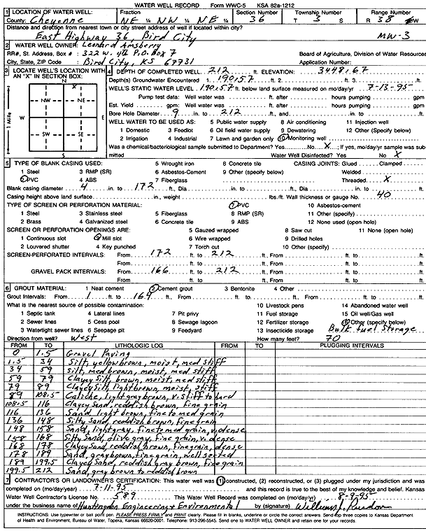
Specific Water Well Detail |
|
|
| Location Info | |||
| Owner: Amsberry, Leonard | Status: Constructed | ||
| Location: T3S, R38W, Sec. 36, NE NW NE | County: Cheyenne | ||
| Directions: In Bird City, East Hwy 36 | |||
| Latitude: 39.7558536 | Longitude: -101.5287628 | Datum NAD 27 | |
| Latitude: 39.7558491 | Longitude: -101.5292065 | Datum NAD 83 | |
| Longitude and latitude calculated by Survey from township-range-section-quarter calls. Only good to within the quarter call accuracy. | |||
| View well on interactive map | |||
| General Info | ||
| Well Depth: 212 ft. | Elevation: 3448.67 ft. | |
| Static Water Level: 190.57 ft. | Est. Yield: gpm. | |
| Comp. Date: 11-Jul-1995 | Well Use: Monitoring well/observation/piezometer | |
| DWR Applic. #: | Other ID: MW 3 | |
| Driller Info | ||
| Driller: Maximum/Kansas City Testing | License #: 589 | |
| Scanned Form | View scan |
|
Chemical Sample Submitted?: No
Water Well disinfected?: | ||
| Ground water encountered: 190.57 ft. , 0 ft. , 0 ft. | ||
| Pump test data: Well water was 0 ft after 0 hours pumping 0 gpm | ||
| Casing Info | ||
| Casing Type: PVC
Casing Joints: |
Diam: 4 in. to 172 ft
Diam: 0 in. to 0 ft Diam: 0 in. to 0 ft | |
| Casing height above land surface: in
Casing Weight: lbs/ft Wall thickness or gauge no.: | ||
| Screen and Perforation Info | ||
| Screen Type: PVC | Screen Openings: Mill slot | |
| Screen-perforated intervals | From: 172 ft to 212 ft
From: 0 ft to 0 ft From: 0 ft to 0 ft | |
| Gravel pack intervals | From: ft to ft | |
| Grout Info | ||
| Grout used: Cement grout | From: 1 to 164 ft
From: 0 to 0 ft From: 0 to 0 ft | |
| Source of Possible Contamination | ||
| Source: OTHER | ||
| Direction from well: W | Distance: 70 ft | |
| Lithologic Log
(Log data entered by KGS.) | ||
| From: 0 ft. to 1.5 ft. | Gravel paving | |
| From: 1.5 ft. to 34 ft. | Silt, yellow brown, moist, medium stiff | |
| From: 34 ft. to 59 ft. | Silt, medium brown, moist, medium stiff | |
| From: 59 ft. to 79 ft. | Clayey silt, brown, moist, medium stiff | |
| From: 79 ft. to 89 ft. | Clayey silt, light brown, moist, stiff | |
| From: 89 ft. to 108.5 ft. | Caliche, light gray brown, very tiff to hard | |
| From: 108.5 ft. to 116 ft. | Clayey sand, reddish brown, fine grain | |
| From: 116 ft. to 136 ft. | Sand, light brown, fine to medium grain | |
| From: 136 ft. to 148 ft. | Silty sand, reddish brown, fine grain | |
| From: 148 ft. to 158 ft. | Sand, light gray, fine to medium grain, very dense | |
| From: 158 ft. to 168 ft. | Silty sand, olive gray, fine grain, very dense | |
| From: 168 ft. to 178 ft. | Clayey sand, reddish brown, fine grain, dense | |
| From: 178 ft. to 189 ft. | Sand, gray brown, fine grain, well seated | |
| From: 189 ft. to 199.5 ft. | Clayey sand, reddish gray brown, fine grain | |
| From: 199.5 ft. to 212 ft. | Sand, gray brown to reddish brown | |