|
|
|
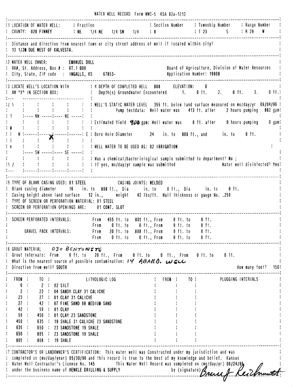
Specific Water Well Detail |
|
|
| Location Info | |||
| Owner: Doll, Emanuel | Status: Constructed | ||
| Location: T23S, R29W, Sec. 8, NE NE SW | County: Finney | ||
| Directions: from Kalvesta. 13.5 mi W | |||
| Latitude: 38.0659199 | Longitude: -100.5283021 | Datum NAD 27 | |
| Latitude: 38.06594 | Longitude: -100.5287277 | Datum NAD 83 | |
| Longitude and latitude calculated by Survey from township-range-section-quarter calls. Only good to within the quarter call accuracy. | |||
| View well on interactive map | |||
| General Info | ||
| Well Depth: 808 ft. | Elevation: ft. | |
| Static Water Level: 355 ft. | Est. Yield: 900 gpm. | |
| Comp. Date: 30-May-1996 | Well Use: Irrigation | |
| DWR Applic. #: 19808 | Other ID: | |
| Links | |
| No Wizard information available. | |
| View info from WIMAS Water Right Data base... | |
| Driller Info | ||
| Driller: Hydro Resources Mid Continent, Inc. | License #: 145 | |
| Scanned Form | View scan |
|
Chemical Sample Submitted?: No
Water Well disinfected?: | ||
| Ground water encountered: 0 ft. , 0 ft. , 0 ft. | ||
| Pump test data: Well water was 413 ft after 2 hours pumping 882 gpm | ||
| Casing Info | ||
| Casing Type: Steel
Casing Joints: |
Diam: 16 in. to 808 ft
Diam: 0 in. to 0 ft Diam: 0 in. to 0 ft | |
| Casing height above land surface: in
Casing Weight: lbs/ft Wall thickness or gauge no.: | ||
| Screen and Perforation Info | ||
| Screen Type: Steel | Screen Openings: Continuous slot | |
| Screen-perforated intervals | From: 455 ft to 805 ft
From: 0 ft to 0 ft From: 0 ft to 0 ft | |
| Gravel pack intervals | From: ft to ft | |
| Grout Info | ||
| Grout used: Bentonite | From: 0 to 20 ft
From: 0 to 0 ft From: 0 to 0 ft | |
| Source of Possible Contamination | ||
| Source: Abandoned water well | ||
| Direction from well: S | Distance: 150 ft | |
| Lithologic Log
(Log data entered by KGS.) | ||
| From: 0 ft. to 2 ft. | silt | |
| From: 2 ft. to 23 ft. | sandy clay caliche | |
| From: 23 ft. to 27 ft. | clay caliche | |
| From: 27 ft. to 42 ft. | fine sand medium sand | |
| From: 42 ft. to 59 ft. | clay | |
| From: 59 ft. to 450 ft. | clay sandstone | |
| From: 450 ft. to 635 ft. | shale caliche sandstone | |
| From: 635 ft. to 650 ft. | sandstone shale | |
| From: 650 ft. to 805 ft. | sandstone shale | |
| From: 805 ft. to 808 ft. | shale | |